↓
 

Miami Land Surveying

Local Land Surveyors in Miami, FL

Miami Florida Land Surveying
(305) 376-7707
Miami Land Surveying
  • Home
  • ALTA Survey
  • Boundary Surveying
  • Construction Survey
  • Drone LiDAR Mapping
  • Elevation Certificate
  • Land Surveying
  • Topographic Survey
  • About Us
  • Blog
  • Contact Us
Home→Tags land survey - Page 2 << 1 2 3 >>

Tag Archives: land survey

Post navigation

← Older posts
Newer posts →

What a Licensed Land Surveyor Can Legally Sign and Certify

Miami Land Surveying Posted on June 5, 2026 by MiamiLSJune 4, 2026
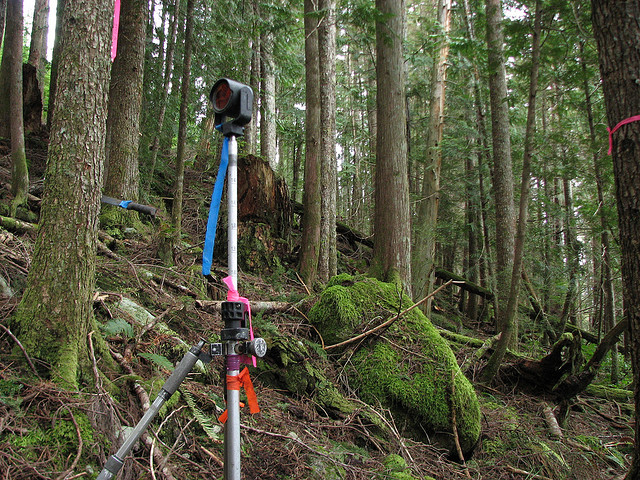
Licensed land surveyor reviewing property records and certified survey plans for boundary verification

Most developers know they need a survey before closing. Fewer know exactly what that survey must include to actually hold up legally. A licensed land surveyor can sign and certify specific documents, and only those documents carry legal weight for permits, lenders and title companies. Anything outside that scope is not a survey. It’s just a map.

What Makes a Land Surveyor Licensed

A land surveyor must hold an active Professional Surveyor and Mapper (PSM) license issued under Chapter 472 of the Florida Statutes. The Florida Department of Business and Professional Regulation (DBPR) issues and tracks these licenses.

Getting a PSM license requires:

  • A degree in surveying and mapping from an accredited program
  • Several years of supervised field experience
  • Passing the Fundamentals of Surveying exam
  • Passing the Principles and Practice of Surveying exam

You can verify any surveyor’s license status for free through the DBPR online database. The license number must also appear on every certified document the surveyor produces. If it’s not there, the document is not legally valid.

What a Licensed Land Surveyor Can Legally Sign

Boundary Survey

A licensed land surveyor can sign and certify a boundary survey. This is the document that shows the exact legal limits of a parcel. It reflects deed research, physical monument locations and field measurements.

A certified boundary survey is the only document a title company will accept to remove boundary-related exceptions from a title policy. It’s also what most building departments require before issuing a permit for new construction or additions.

Elevation Certificate

A licensed land surveyor can sign and certify a FEMA Elevation Certificate. This document records the elevation of a structure relative to the Base Flood Elevation (BFE) on the FEMA Flood Insurance Rate Map.

Lenders require it on properties in Special Flood Hazard Areas. Insurance companies use it to set flood insurance premiums. Without a PSM signature, FEMA does not recognize it as valid.

ALTA/NSPS Land Title Survey

A licensed land surveyor can sign and certify an ALTA/NSPS Land Title Survey. This is the survey type commercial lenders and title companies require on income-producing properties and larger transactions.

It follows a national standard set jointly by the American Land Title Association (ALTA) and the National Society of Professional Surveyors (NSPS). The surveyor must certify that the survey meets those standards on the face of the document. No PSM signature means no valid ALTA survey.

Subdivision Plat

A licensed land surveyor must sign and seal every subdivision plat before it can be recorded with the county. Florida Statutes Chapter 177 requires this. The plat creates the legal lots, streets and easements that form a subdivision. A county will not record a plat without a PSM seal.

Topographic Survey

A licensed land surveyor can sign and certify a topographic survey. This document maps the elevation and physical features of a site. Engineers and architects use it for grading, drainage and site design.

Construction Survey Documents

A licensed land surveyor can certify construction staking records and as-built surveys. These confirm that structures were placed where the approved plans required.

What a Licensed Land Surveyor Cannot Do

This matters as much as what they can do.

A PSM license does not authorize a surveyor to:

  • Give a legal opinion on title or ownership
  • Appraise land value
  • Practice civil engineering without a separate PE license
  • Provide legal advice on deed disputes or boundary litigation
  • Issue zoning opinions or land use determinations

If a boundary dispute ends up in court, the surveyor can testify about measurements and deed interpretation. They cannot act as the property owner’s attorney. The two roles don’t overlap.

Some surveyors also hold a Professional Engineer (PE) license. When that’s the case, they can certify engineering documents under that separate license. But the PSM license alone doesn’t cover it.

Why the Signature Matters to Developers

Permits Won’t Move Without It

Most local building departments require a survey signed and sealed by a licensed PSM before they’ll issue a permit. A sketch, a GIS printout or an unsigned drawing doesn’t satisfy that requirement. The permit application stalls until a certified survey is submitted.

Lenders Check the Seal

Commercial lenders review the surveyor’s license number and certification language before approving a construction loan. If the survey comes from an unlicensed provider, the lender’s underwriting team will reject it. That stops the loan.

Title Companies Rely on the Certification

When a title company issues a policy without boundary exceptions, they’re relying on the surveyor’s professional certification. The surveyor is legally responsible for the accuracy of the document. That’s what gives the certification its weight. An uncertified document gives the title company nothing to stand on.

How to Confirm a Surveyor’s License Before You Hire

Three steps. Takes five minutes.

  1. Ask the surveyor for their PSM license number before signing anything.
  2. Go to the Florida DBPR website and search the license database by name or number.
  3. Confirm the license is active and has no disciplinary history.

If the license is expired, suspended or shows a recent complaint, stop the conversation. Hire someone else. A survey signed by a lapsed PSM has no legal standing and will be rejected by permits, lenders and title companies.

Frequently Asked Questions

What does a licensed land surveyor legally certify?

A licensed Professional Surveyor and Mapper (PSM) can legally certify boundary surveys, elevation certificates, ALTA/NSPS land title surveys, subdivision plats, topographic surveys and construction survey documents. Each certified document carries the surveyor’s license number and professional seal, which gives it legal standing for permits, title insurance and lender review.

Can a licensed land surveyor give a legal opinion on a boundary dispute?

No. A PSM can testify about measurements, deed calls and survey findings, but they can’t provide legal advice or title opinions. That falls under the practice of law. If a boundary dispute escalates, you need a real estate attorney alongside the surveyor’s certified documentation.

What happens if a survey isn’t signed by a licensed surveyor?

It has no legal standing. The building department won’t accept it for a permit. A lender won’t accept it for a loan. A title company won’t use it to remove exceptions from a policy. The document is effectively useless for any official purpose.

Does a PSM license cover engineering work?

No. A PSM license covers surveying and mapping only. A surveyor who also holds a Professional Engineer (PE) license can certify engineering documents, but only under that separate PE license. The two licenses cover different scopes of work and can’t be substituted for each other.

How do I verify a land surveyor’s license is active?

Search the Florida Department of Business and Professional Regulation (DBPR) online license database. You can search by the surveyor’s name or license number. The result shows whether the license is active, expired or has any disciplinary actions on record. Always check before hiring.

Posted in land surveying | Tagged land survey, land surveying miami, land surveyor, licensed land surveyor

What an ALTA Survey Includes vs. What Must Be Requested Separately

Miami Land Surveying Posted on May 8, 2026 by MiamiLSMay 5, 2026
Alta land survey documents reviewed during construction loan closing process
#image_title

When people order an ALTA survey, they expect everything to be covered.

That is not how it works.

An ALTA survey gives a strong starting point. It shows the shape of the land, what sits on it, and how it connects to nearby properties. It also checks legal records against real conditions.

But it only shows what is requested.

If something is not listed, it does not show up.

That is where problems begin.

What an ALTA Survey Includes

An ALTA survey follows a set standard. Lenders and title companies rely on it before closing.

At the base level, it shows:

  • Property boundaries
  • Buildings and visible structures
  • Easements that affect use
  • Access points like roads and driveways
  • Encroachments from nearby properties

It also compares recorded documents with what exists on the ground. If something does not match, it gets flagged.

This base survey helps confirm that the property matches its legal description.

Still, it does not cover every detail.

Why the Base Survey Is Not Enough

No two properties are the same.

Some sites are simple. Others have shared access, unclear records, or limits that affect how the land can be used.

A basic ALTA survey may not show:

  • Flood zone classification
  • Utility locations
  • Zoning details
  • Parking layout

These details matter.

Flood zones affect insurance. Zoning affects what you can build. Utilities affect whether a project can move forward.

If these are not included, the survey leaves gaps.

Those gaps usually show up late.

That slows everything down.

What Must Be Requested Separately

Extra details come from the ALTA Table A Items List.

This list includes optional survey items. Each one adds a layer of information to the survey.

Common examples include:

  • Flood zone classification
  • Zoning information
  • Utility locations
  • Parking spaces and layout
  • Building heights and dimensions
  • Access points and curb cuts
  • Signs of shared use like driveways or paths

Each item must be selected before the survey begins.

Surveyors follow the request. They do not add items on their own.

If something is not listed, it will not appear in the final survey.

Why Table A Items Matter

These optional items often decide how smooth a deal will go.

Take access.

A property may look like it connects to a public road. The survey may show that access crosses another parcel. That creates a legal issue that needs to be addressed.

Now think about utilities.

A site may look ready for development. Then the survey shows no clear utility connection. That can stop a project.

Flood zones cause issues as well.

If a property sits in a flood zone, insurance costs can change fast. Lenders need that information before approving a deal.

These are not small details.

They affect cost, timing, and approval.

Where Requests Go Wrong

Most problems start early.

Buyers assume the survey includes everything. Lenders expect certain details but do not always list them clearly.

That creates gaps.

The survey gets completed, and missing details show up later.

Now the survey needs updates.

That means more time and more cost.

It also creates pressure close to closing, where delays hurt the most.

How to Request the Right Survey

The request should match the goal of the project.

A development site needs more detail. A simple purchase may need less.

Still, some items come up often:

  • Flood zone data
  • Access confirmation
  • Utility locations
  • Zoning information

These protect both the buyer and the lender.

It is better to include them early than fix missing pieces later.

The Role of the Surveyor

A surveyor follows the scope that is given.

They do not decide which Table A items to include. That choice comes from the client, lender, or title company.

A good surveyor will still point out gaps when they see them.

They have seen deals slow down because of small missing details.

That experience helps avoid repeat work.

Why This Matters Before Closing

Timing matters.

An ALTA survey often comes near the end of a deal. If something is missing, there may not be enough time to fix it without delay.

That is why the scope must be clear from the start.

A complete survey answers questions early. It reduces surprises and keeps the deal moving.

When the scope is weak, the opposite happens.

Get the Scope Right From the Start

An ALTA survey only shows what is requested.

The base covers key details. The rest depends on the ALTA Table A Items List.

If the scope is clear, the survey works.

If not, problems show up late.

Most delays do not come from the survey itself.

They come from missing details at the start.
Posted in land surveying | Tagged alta land survey, alta land table A, land survey, Land survey requirements, land surveying miami

Where LiDAR Mapping Helps Before Design Starts

Miami Land Surveying Posted on May 5, 2026 by MiamiLSMay 5, 2026

A site can look flat and ready. It rarely is.

LiDAR mapping gives you a clear view of the ground before design begins. It shows elevation changes, drainage paths, and hidden features so you can plan with real data instead of assumptions.

That early clarity helps avoid redesign, delays, and extra cost.

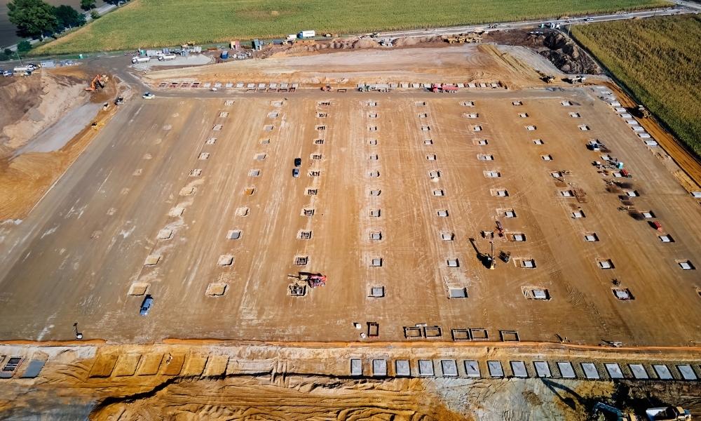
LiDAR mapping aerial view of a construction site showing graded soil, foundation layout points, and earthwork preparation for development planning
#image_title

What does LiDAR mapping show before design starts?

LiDAR mapping shows detailed ground elevation, drainage paths, and surface features before design begins. It helps identify slopes, low areas, and hidden conditions that affect grading, drainage, and layout. This allows engineers and developers to plan accurately and avoid costly changes later in the project.

LiDAR mapping uses a laser from a drone or aircraft. It scans the surface and builds a detailed model of the ground.

It shows more than outlines. It shows how the land actually moves.

You can see:

  • small elevation changes
  • natural drainage flow
  • dips where water collects
  • features under light vegetation

Even small height changes matter. Water follows them. So does your design.

Why does LiDAR mapping matter before design?

LiDAR mapping provides accurate site data early. This helps prevent redesign, reduces construction delays, and avoids added costs. When engineers understand the land from the start, they can create plans that match real conditions instead of adjusting later.

Most issues do not show up at the start. They appear after plans are finished.

Then changes begin. Costs rise. Timelines stretch.

LiDAR mapping shifts that timing.

You see the real site early. The design follows the land. You avoid forcing a plan onto conditions that do not support it.

That keeps progress steady and reduces rework.

When should you use LiDAR mapping on a project?

LiDAR mapping works best for large or complex sites where elevation, drainage, and access matter. It is useful when vegetation blocks visibility or when full site coverage is needed early. It helps developers, engineers, and property owners understand site conditions before planning begins.

It becomes useful when a site gets harder to read.

This includes:

  • large properties
  • new developments
  • long access routes
  • uneven or sloped land

Walking a site only shows parts of it. Some areas stay hidden or hard to reach.

LiDAR mapping captures everything at once. You get full coverage, not scattered points.

That leads to better planning decisions early.

How does LiDAR mapping help with drainage planning?

LiDAR mapping shows how water moves across a site. It identifies slopes, low areas, and flow paths that affect grading and runoff. This allows engineers to design proper drainage systems early and reduce the risk of flooding or standing water after construction.

Water shapes most site problems.

Rain does not need much space to cause issues. A small dip can hold water. A slight slope can direct it toward structures.

LiDAR mapping shows these patterns clearly.

You can find:

  • low spots that hold water
  • slopes pushing water in the wrong direction
  • areas that need grading work

This allows drainage planning to happen early, not after problems show up.

Why does LiDAR mapping reduce plan revisions?

LiDAR mapping provides accurate site data before design begins. Plans based on real conditions are less likely to require changes during review or construction. This helps avoid delays, reduces back-and-forth with reviewers, and keeps the project moving forward.

Plans must match the site.

If they do not, they come back with comments. Then revisions follow. Then more waiting.

LiDAR mapping reduces that cycle.

You start with better data. Plans match real conditions. That cuts avoidable corrections.

You still go through review, but with fewer surprises.

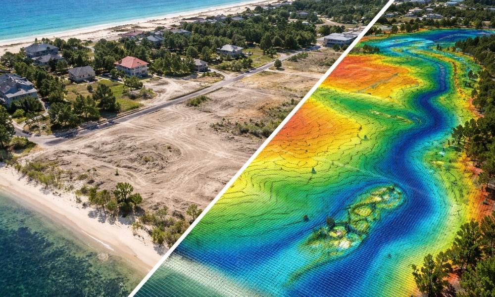
LiDAR mapping visualization comparing a real coastal development site with a digital elevation heatmap showing terrain changes, drainage patterns, and topographic variation
#image_title

Can LiDAR mapping see through vegetation?

LiDAR mapping can filter through light vegetation to reveal the ground surface. This helps identify elevation changes and hidden features that are not visible from above. It improves planning accuracy, especially on sites where trees or brush cover important ground conditions.

Vegetation hides detail.

A site may look simple because you cannot see the surface clearly.

LiDAR mapping can filter through lighter cover. It gives a clearer picture of the ground.

This helps with:

  • clearing decisions
  • building placement
  • access planning

You avoid hidden issues that show up later.

How does LiDAR mapping work with an ALTA Survey?

LiDAR mapping supports early planning, while an ALTA Survey confirms legal and boundary details later. LiDAR helps with design decisions such as grading and layout. An ALTA Survey verifies property lines, easements, and improvements for title and transaction purposes. Both are used at different stages of a project.

LiDAR mapping and an ALTA Survey serve different roles.

LiDAR mapping comes first. It helps shape early design decisions.

An ALTA Survey comes later. It confirms boundaries, easements, and recorded features tied to ownership and title.

Using both at the right time keeps the project aligned from planning to closing.

When is LiDAR mapping not enough?

LiDAR mapping is not enough when precise boundary, legal, or construction layout data is required. Projects still need boundary surveys, construction staking, and field verification. LiDAR provides surface data, but it does not replace detailed surveys needed for legal accuracy and construction execution.

LiDAR mapping shows surface conditions well.

It does not replace:

  • boundary surveys
  • construction staking
  • detailed field checks

Relying on it alone creates gaps.

Use it for early planning. Then move into the right surveys as the project advances.

How LiDAR mapping saves time early in a project

LiDAR mapping collects large amounts of site data quickly. This allows design work to begin sooner and reduces delays caused by incomplete information. Faster data collection helps teams make decisions earlier and move projects forward with fewer interruptions.

Time matters on every project.

Traditional surveys take longer on large or complex sites.

LiDAR mapping speeds up the early stage. Data comes in faster. Decisions happen sooner.

That keeps the project moving instead of waiting on missing information.

What happens if you skip LiDAR mapping?

Skipping LiDAR mapping can lead to design errors, drainage issues, and costly revisions. Without accurate early data, teams rely on assumptions. This often results in delays, added costs, and construction changes. Early mapping reduces risk by providing a clear understanding of the site from the start.

Skipping early mapping leads to guesswork.

Plans may look fine at first. Problems appear later.

You may deal with:

  • grading changes during construction
  • water issues after building
  • delays from revisions
  • added costs to fix mistakes

Most of this comes from missing site data.

What to Keep in Mind

The land already has a shape.

Your design has to follow it.

LiDAR mapping helps you see that shape early. That changes how you plan and how the project moves forward.

Skipping it does not save time. It only shifts the problems to a later stage, when they cost more to fix.

Posted in land surveying | Tagged alta land survey, Drone LiDAR mapping, land survey

Post navigation

← Older posts
Newer posts →

Contact Us!

Select Your City

  • Aventura
  • Coral Gables
  • Cutler Bay
  • Doral
  • Hialeah
  • Homestead
  • Miami Beach
  • Miami Gardens
  • Miami Lakes
  • North Miami
  • North Miami Beach

The owner of this website, USA Surveying & Engineering, LLC., provides coordination of professional land surveying and engineering services in all 50 states. The professional surveying and engineering services provided to you will be conducted by fully licensed professionals in your state.

Privacy Policy | Terms of Use
↑