↓
 

Miami Land Surveying

Local Land Surveyors in Miami, FL

Miami Florida Land Surveying
(305) 376-7707
Miami Land Surveying
  • Home
  • ALTA Survey
  • Boundary Surveying
  • Construction Survey
  • Drone LiDAR Mapping
  • Elevation Certificate
  • Land Surveying
  • Topographic Survey
  • About Us
  • Blog
  • Contact Us
Home→Tags Drone LiDAR mapping

Tag Archives: Drone LiDAR mapping

Where LiDAR Mapping Helps Before Design Starts

Miami Land Surveying Posted on May 5, 2026 by MiamiLSMay 5, 2026

A site can look flat and ready. It rarely is.

LiDAR mapping gives you a clear view of the ground before design begins. It shows elevation changes, drainage paths, and hidden features so you can plan with real data instead of assumptions.

That early clarity helps avoid redesign, delays, and extra cost.

LiDAR mapping aerial view of a construction site showing graded soil, foundation layout points, and earthwork preparation for development planning
#image_title

What does LiDAR mapping show before design starts?

LiDAR mapping shows detailed ground elevation, drainage paths, and surface features before design begins. It helps identify slopes, low areas, and hidden conditions that affect grading, drainage, and layout. This allows engineers and developers to plan accurately and avoid costly changes later in the project.

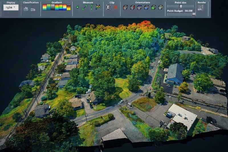
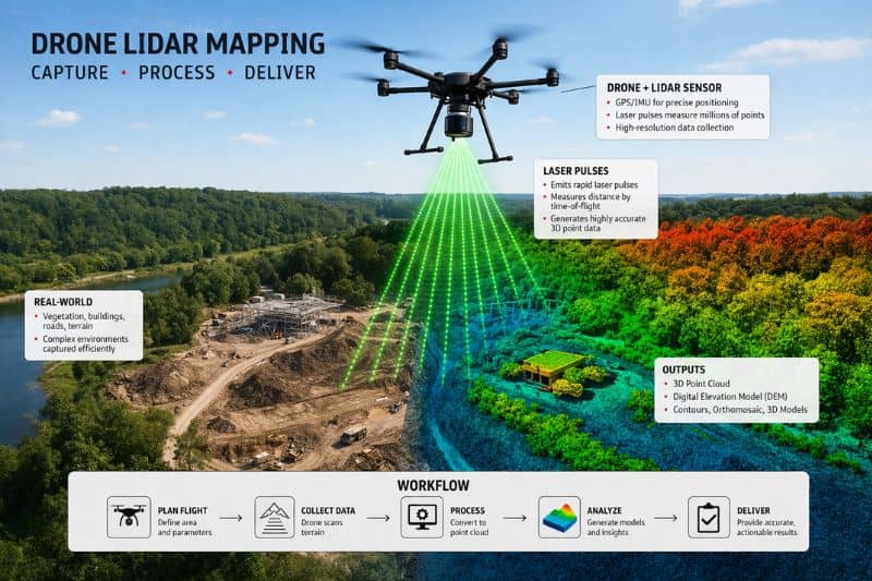
LiDAR mapping uses a laser from a drone or aircraft. It scans the surface and builds a detailed model of the ground.

It shows more than outlines. It shows how the land actually moves.

You can see:

  • small elevation changes
  • natural drainage flow
  • dips where water collects
  • features under light vegetation

Even small height changes matter. Water follows them. So does your design.

Why does LiDAR mapping matter before design?

LiDAR mapping provides accurate site data early. This helps prevent redesign, reduces construction delays, and avoids added costs. When engineers understand the land from the start, they can create plans that match real conditions instead of adjusting later.

Most issues do not show up at the start. They appear after plans are finished.

Then changes begin. Costs rise. Timelines stretch.

LiDAR mapping shifts that timing.

You see the real site early. The design follows the land. You avoid forcing a plan onto conditions that do not support it.

That keeps progress steady and reduces rework.

When should you use LiDAR mapping on a project?

LiDAR mapping works best for large or complex sites where elevation, drainage, and access matter. It is useful when vegetation blocks visibility or when full site coverage is needed early. It helps developers, engineers, and property owners understand site conditions before planning begins.

It becomes useful when a site gets harder to read.

This includes:

  • large properties
  • new developments
  • long access routes
  • uneven or sloped land

Walking a site only shows parts of it. Some areas stay hidden or hard to reach.

LiDAR mapping captures everything at once. You get full coverage, not scattered points.

That leads to better planning decisions early.

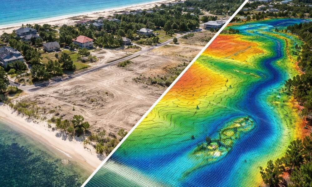
How does LiDAR mapping help with drainage planning?

LiDAR mapping shows how water moves across a site. It identifies slopes, low areas, and flow paths that affect grading and runoff. This allows engineers to design proper drainage systems early and reduce the risk of flooding or standing water after construction.

Water shapes most site problems.

Rain does not need much space to cause issues. A small dip can hold water. A slight slope can direct it toward structures.

LiDAR mapping shows these patterns clearly.

You can find:

  • low spots that hold water
  • slopes pushing water in the wrong direction
  • areas that need grading work

This allows drainage planning to happen early, not after problems show up.

Why does LiDAR mapping reduce plan revisions?

LiDAR mapping provides accurate site data before design begins. Plans based on real conditions are less likely to require changes during review or construction. This helps avoid delays, reduces back-and-forth with reviewers, and keeps the project moving forward.

Plans must match the site.

If they do not, they come back with comments. Then revisions follow. Then more waiting.

LiDAR mapping reduces that cycle.

You start with better data. Plans match real conditions. That cuts avoidable corrections.

You still go through review, but with fewer surprises.

LiDAR mapping visualization comparing a real coastal development site with a digital elevation heatmap showing terrain changes, drainage patterns, and topographic variation
#image_title

Can LiDAR mapping see through vegetation?

LiDAR mapping can filter through light vegetation to reveal the ground surface. This helps identify elevation changes and hidden features that are not visible from above. It improves planning accuracy, especially on sites where trees or brush cover important ground conditions.

Vegetation hides detail.

A site may look simple because you cannot see the surface clearly.

LiDAR mapping can filter through lighter cover. It gives a clearer picture of the ground.

This helps with:

  • clearing decisions
  • building placement
  • access planning

You avoid hidden issues that show up later.

How does LiDAR mapping work with an ALTA Survey?

LiDAR mapping supports early planning, while an ALTA Survey confirms legal and boundary details later. LiDAR helps with design decisions such as grading and layout. An ALTA Survey verifies property lines, easements, and improvements for title and transaction purposes. Both are used at different stages of a project.

LiDAR mapping and an ALTA Survey serve different roles.

LiDAR mapping comes first. It helps shape early design decisions.

An ALTA Survey comes later. It confirms boundaries, easements, and recorded features tied to ownership and title.

Using both at the right time keeps the project aligned from planning to closing.

When is LiDAR mapping not enough?

LiDAR mapping is not enough when precise boundary, legal, or construction layout data is required. Projects still need boundary surveys, construction staking, and field verification. LiDAR provides surface data, but it does not replace detailed surveys needed for legal accuracy and construction execution.

LiDAR mapping shows surface conditions well.

It does not replace:

  • boundary surveys
  • construction staking
  • detailed field checks

Relying on it alone creates gaps.

Use it for early planning. Then move into the right surveys as the project advances.

How LiDAR mapping saves time early in a project

LiDAR mapping collects large amounts of site data quickly. This allows design work to begin sooner and reduces delays caused by incomplete information. Faster data collection helps teams make decisions earlier and move projects forward with fewer interruptions.

Time matters on every project.

Traditional surveys take longer on large or complex sites.

LiDAR mapping speeds up the early stage. Data comes in faster. Decisions happen sooner.

That keeps the project moving instead of waiting on missing information.

What happens if you skip LiDAR mapping?

Skipping LiDAR mapping can lead to design errors, drainage issues, and costly revisions. Without accurate early data, teams rely on assumptions. This often results in delays, added costs, and construction changes. Early mapping reduces risk by providing a clear understanding of the site from the start.

Skipping early mapping leads to guesswork.

Plans may look fine at first. Problems appear later.

You may deal with:

  • grading changes during construction
  • water issues after building
  • delays from revisions
  • added costs to fix mistakes

Most of this comes from missing site data.

What to Keep in Mind

The land already has a shape.

Your design has to follow it.

LiDAR mapping helps you see that shape early. That changes how you plan and how the project moves forward.

Skipping it does not save time. It only shifts the problems to a later stage, when they cost more to fix.

Posted in land surveying | Tagged alta land survey, Drone LiDAR mapping, land survey

Why LiDAR Accuracy Alone Fails in Real Projects

Miami Land Surveying Posted on March 31, 2026 by MiamiLSMarch 31, 2026

LiDAR mapping services have quickly become a go-to solution for collecting topographic data in civil engineering and land development. With the ability to capture millions of data points and deliver highly detailed terrain models, they are often marketed as a fast and accurate alternative to traditional surveying.

But here’s the reality: high accuracy does not always mean reliable data.

Many projects run into costly issues—even when LiDAR datasets meet standard accuracy requirements. The problem isn’t just accuracy. It’s how that data is collected, controlled, and prepared for real-world design.

LiDAR point cloud used for topographic mapping and site development planning in a suburban area

The Growing Use of LiDAR Mapping in Civil Projects

LiDAR is widely used across the industry for:

  • Site development
  • Infrastructure planning
  • Solar farm design
  • Flood and drainage studies

Its popularity comes from speed and efficiency. Large areas can be mapped quickly, even in difficult terrain, and are often used alongside topographic surveys to support accurate site development and planning.

However, as more providers enter the market, the quality of LiDAR data has become inconsistent. Not all LiDAR mapping services deliver the same level of reliability—especially when it comes to engineering design.

The Misconception About LiDAR Accuracy

What Most Providers Focus On

Many LiDAR providers highlight metrics like vertical accuracy and RMSE, often based on established LiDAR accuracy standards from organizations like the American Society for Photogrammetry and Remote Sensing (ASPRS).

  • Vertical accuracy (e.g., ±0.10 ft)
  • RMSE compliance
  • Point density

While these numbers look impressive, they don’t tell the full story.

Is LiDAR Data Accurate?

Yes, LiDAR data can be highly accurate—but accuracy alone does not guarantee that it will work for engineering design. A dataset can meet accuracy standards and still contain hidden issues that cause major problems during grading or drainage planning.

Why Accuracy Metrics Don’t Tell the Full Story

A LiDAR dataset may look perfect on paper but still fail in real projects due to:

  • Inconsistent elevation control
  • Misaligned datasets
  • Missing terrain features
  • Poor surface modeling

This is where many projects begin to break down.

The Real Reason LiDAR Data Fails in Projects

Comparison of raw LiDAR point cloud and processed engineering-ready surface with drone scanning, showing grading and drainage improvements on a site
Visual comparison of raw LiDAR vs processed surface for accurate grading and drainage design.

What Can Cause LiDAR to Fail?

LiDAR can fail due to poor survey control, vertical bias, incorrect calibration, or incomplete terrain interpretation. Even when the data appears accurate, these issues can lead to grading errors, drainage failures, and expensive rework during construction.

Vertical Control Issues

One of the most common problems is inconsistent vertical control.

This can happen when:

  • Ground control points are limited or inaccurate
  • Different datums are used across the project
  • Benchmarks are outdated or not verified

Even small elevation errors can disrupt:

  • Drainage flow
  • Sewer connections
  • Earthwork calculations

Can LiDAR Be Inaccurate?

Yes, LiDAR can be inaccurate—especially when proper survey control and calibration are missing. Errors may not be obvious in raw data but can show up later during design, where precision is critical.

Hidden LiDAR Bias (The Biggest Risk)

Not all errors are random. Some are systematic—this is known as bias.

Bias can:

  • Shift entire surfaces up or down
  • Distort grading plans
  • Misrepresent cut and fill volumes

Unlike random noise, bias does not cancel out. It stays consistent—and dangerous.

Poor Surface Interpretation

Raw LiDAR data is not the same as engineering-ready data.

Many datasets lack:

  • Defined breaklines
  • Clear drainage paths
  • Accurate edges (curbs, pavement, channels)

Without proper interpretation, the surface model becomes unreliable.

Sensitivity in Modern Design Software

Today’s design tools (like Civil 3D) are extremely sensitive to surface data.

Even small inconsistencies can cause:

  • Surface distortions
  • Incorrect grading results
  • Drainage modeling errors

This means minor data issues can quickly turn into major project risks.

What Engineering-Grade LiDAR Mapping Should Include

Survey-Controlled Data Collection

Reliable LiDAR mapping services start with proper survey control, including:

  • Verified ground control points
  • Consistent horizontal and vertical datums
  • Independent accuracy checks

This ensures the data aligns with real-world conditions.

What Factors Affect LiDAR Accuracy?

Several factors influence LiDAR accuracy, including ground control quality, sensor calibration, flight conditions, and data processing methods. Without proper QA/QC procedures, even high-density data can produce unreliable results.

Bias-Free Elevation Data

Engineering-grade LiDAR includes:

  • Calibration checks
  • Cross-validation against ground truth
  • Elimination of systematic errors

The goal is not just accuracy—but consistency.

Complete Surface Modeling and Breaklines

A usable dataset should include:

  • Drainage-aware surfaces
  • Defined edges and features
  • Continuous terrain models

This allows engineers to design with confidence.

Design-Ready Deliverables

The final output should be ready for:

  • Grading plans
  • Drainage design
  • Construction workflows

Not just raw data—but actionable information.

Why This Matters for Your Project

Choosing the right LiDAR mapping services can directly impact your project outcome.

With high-quality data, you get:

  • Reduced construction risk
  • Accurate grading and drainage design
  • Fewer delays and change orders
  • Better overall project performance

Poor data, on the other hand, can lead to costly mistakes that are difficult to fix later.

Choosing the Right LiDAR Mapping Services

Not all providers deliver engineering-grade results.

When selecting a provider, look for:

  • A background in surveying and civil engineering
  • Proven QA/QC processes
  • Experience with design workflows
  • Fully interpreted, design-ready deliverables

Avoid providers that focus only on data collection without considering how the data will be used.

Frequently Asked Questions About LiDAR Mapping

Is LiDAR data accurate?

LiDAR data can be highly accurate, but accuracy alone does not ensure reliability. Factors like survey control, calibration, and processing play a major role in how usable the data is for engineering design.

What can cause LiDAR to fail?

LiDAR can fail due to poor control, vertical bias, missing breaklines, or inadequate surface modeling. These issues often lead to grading and drainage problems in real projects.

Can LiDAR be inaccurate?

Yes, LiDAR can be inaccurate if proper workflows are not followed. Even small errors can create major design issues when the data is used in engineering software.

What factors affect LiDAR accuracy?

Accuracy depends on ground control, sensor calibration, environmental conditions, and data processing. High-quality LiDAR mapping services use strict QA/QC processes to ensure reliable results.

Posted in drone lidar mapping | Tagged Drone LiDAR mapping, Engineering-grade LiDAR, LiDAR accuracy, Topographic surveys
Get Quote Button

Select Your City

  • Aventura
  • Coral Gables
  • Cutler Bay
  • Doral
  • Hialeah
  • Homestead
  • Miami Beach
  • Miami Gardens
  • Miami Lakes
  • North Miami
  • North Miami Beach

The owner of this website, USA Surveying & Engineering, LLC., provides coordination of professional land surveying and engineering services in all 50 states. The professional surveying and engineering services provided to you will be conducted by fully licensed professionals in your state.

Privacy Policy | Terms of Use
↑