
LiDAR mapping services have quickly become a go-to solution for collecting topographic data in civil engineering and land development. With the ability to capture millions of data points and deliver highly detailed terrain models, they are often marketed as a fast and accurate alternative to traditional surveying.
But here’s the reality: high accuracy does not always mean reliable data.
Many projects run into costly issues—even when LiDAR datasets meet standard accuracy requirements. The problem isn’t just accuracy. It’s how that data is collected, controlled, and prepared for real-world design.
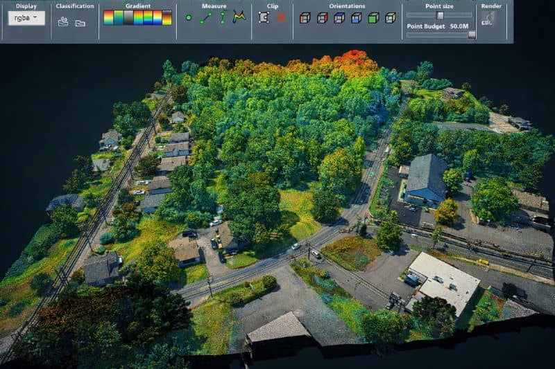
The Growing Use of LiDAR Mapping in Civil Projects
LiDAR is widely used across the industry for:
- Site development
- Infrastructure planning
- Solar farm design
- Flood and drainage studies
Its popularity comes from speed and efficiency. Large areas can be mapped quickly, even in difficult terrain, and are often used alongside topographic surveys to support accurate site development and planning.
However, as more providers enter the market, the quality of LiDAR data has become inconsistent. Not all LiDAR mapping services deliver the same level of reliability—especially when it comes to engineering design.
The Misconception About LiDAR Accuracy
What Most Providers Focus On
Many LiDAR providers highlight metrics like vertical accuracy and RMSE, often based on established LiDAR accuracy standards from organizations like the American Society for Photogrammetry and Remote Sensing (ASPRS).
- Vertical accuracy (e.g., ±0.10 ft)
- RMSE compliance
- Point density
While these numbers look impressive, they don’t tell the full story.
Is LiDAR Data Accurate?
Yes, LiDAR data can be highly accurate—but accuracy alone does not guarantee that it will work for engineering design. A dataset can meet accuracy standards and still contain hidden issues that cause major problems during grading or drainage planning.
Why Accuracy Metrics Don’t Tell the Full Story
A LiDAR dataset may look perfect on paper but still fail in real projects due to:
- Inconsistent elevation control
- Misaligned datasets
- Missing terrain features
- Poor surface modeling
This is where many projects begin to break down.
The Real Reason LiDAR Data Fails in Projects
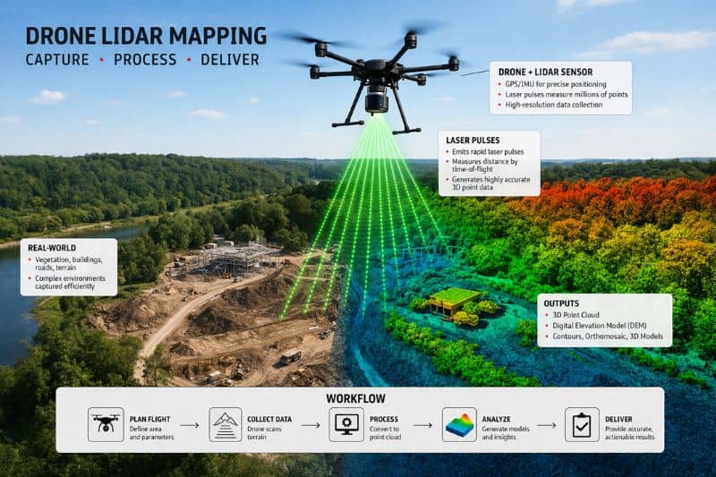
What Can Cause LiDAR to Fail?
LiDAR can fail due to poor survey control, vertical bias, incorrect calibration, or incomplete terrain interpretation. Even when the data appears accurate, these issues can lead to grading errors, drainage failures, and expensive rework during construction.
Vertical Control Issues
One of the most common problems is inconsistent vertical control.
This can happen when:
- Ground control points are limited or inaccurate
- Different datums are used across the project
- Benchmarks are outdated or not verified
Even small elevation errors can disrupt:
- Drainage flow
- Sewer connections
- Earthwork calculations
Can LiDAR Be Inaccurate?
Yes, LiDAR can be inaccurate—especially when proper survey control and calibration are missing. Errors may not be obvious in raw data but can show up later during design, where precision is critical.
Hidden LiDAR Bias (The Biggest Risk)
Not all errors are random. Some are systematic—this is known as bias.
Bias can:
- Shift entire surfaces up or down
- Distort grading plans
- Misrepresent cut and fill volumes
Unlike random noise, bias does not cancel out. It stays consistent—and dangerous.
Poor Surface Interpretation
Raw LiDAR data is not the same as engineering-ready data.
Many datasets lack:
- Defined breaklines
- Clear drainage paths
- Accurate edges (curbs, pavement, channels)
Without proper interpretation, the surface model becomes unreliable.
Sensitivity in Modern Design Software
Today’s design tools (like Civil 3D) are extremely sensitive to surface data.
Even small inconsistencies can cause:
- Surface distortions
- Incorrect grading results
- Drainage modeling errors
This means minor data issues can quickly turn into major project risks.
What Engineering-Grade LiDAR Mapping Should Include
Survey-Controlled Data Collection
Reliable LiDAR mapping services start with proper survey control, including:
- Verified ground control points
- Consistent horizontal and vertical datums
- Independent accuracy checks
This ensures the data aligns with real-world conditions.
What Factors Affect LiDAR Accuracy?
Several factors influence LiDAR accuracy, including ground control quality, sensor calibration, flight conditions, and data processing methods. Without proper QA/QC procedures, even high-density data can produce unreliable results.
Bias-Free Elevation Data
Engineering-grade LiDAR includes:
- Calibration checks
- Cross-validation against ground truth
- Elimination of systematic errors
The goal is not just accuracy—but consistency.
Complete Surface Modeling and Breaklines
A usable dataset should include:
- Drainage-aware surfaces
- Defined edges and features
- Continuous terrain models
This allows engineers to design with confidence.
Design-Ready Deliverables
The final output should be ready for:
- Grading plans
- Drainage design
- Construction workflows
Not just raw data—but actionable information.
Why This Matters for Your Project
Choosing the right LiDAR mapping services can directly impact your project outcome.
With high-quality data, you get:
- Reduced construction risk
- Accurate grading and drainage design
- Fewer delays and change orders
- Better overall project performance
Poor data, on the other hand, can lead to costly mistakes that are difficult to fix later.
Choosing the Right LiDAR Mapping Services
Not all providers deliver engineering-grade results.
When selecting a provider, look for:
- A background in surveying and civil engineering
- Proven QA/QC processes
- Experience with design workflows
- Fully interpreted, design-ready deliverables
Avoid providers that focus only on data collection without considering how the data will be used.
Frequently Asked Questions About LiDAR Mapping
Is LiDAR data accurate?
LiDAR data can be highly accurate, but accuracy alone does not ensure reliability. Factors like survey control, calibration, and processing play a major role in how usable the data is for engineering design.
What can cause LiDAR to fail?
LiDAR can fail due to poor control, vertical bias, missing breaklines, or inadequate surface modeling. These issues often lead to grading and drainage problems in real projects.
Can LiDAR be inaccurate?
Yes, LiDAR can be inaccurate if proper workflows are not followed. Even small errors can create major design issues when the data is used in engineering software.
What factors affect LiDAR accuracy?
Accuracy depends on ground control, sensor calibration, environmental conditions, and data processing. High-quality LiDAR mapping services use strict QA/QC processes to ensure reliable results.