↓
 

Miami Land Surveying

Local Land Surveyors in Miami, FL

Miami Florida Land Surveying
(305) 376-7707
Miami Land Surveying
  • Home
  • ALTA Survey
  • Boundary Surveying
  • Construction Survey
  • Drone LiDAR Mapping
  • Elevation Certificate
  • Land Surveying
  • Lot Survey – Closing Survey
  • Topographic Survey
  • About Us
  • Contact Us
Home→Tags elevation certificate

Tag Archives: elevation certificate

How To Find Your Home On FEMA’s Flood Insurance Rate Maps

Miami Land Surveying Posted on July 28, 2019 by MiamiLSMarch 10, 2018

What are FEMA flood maps?
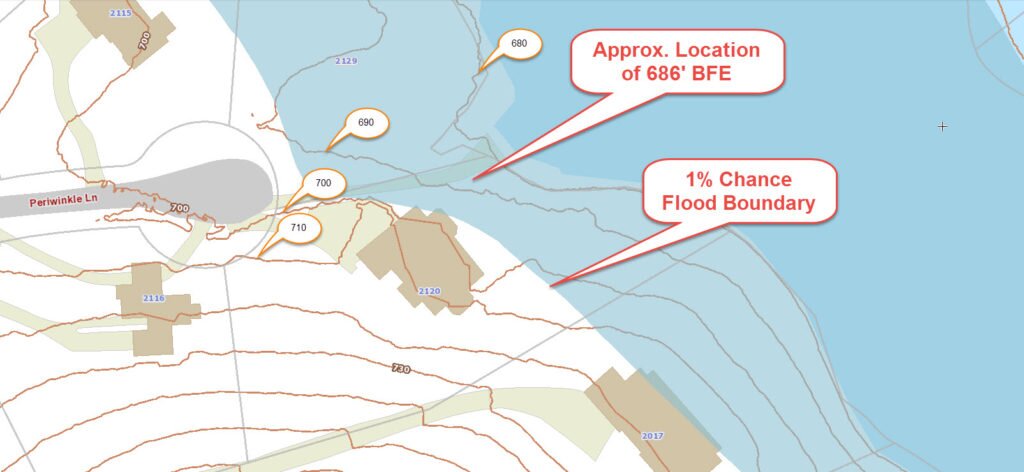
flood survey - elevation certificateFEMA’s Flood Insurance Rate Maps (FIRMs) or just Flood Maps are provided after a flood risk assessment has been completed or updated for a community.  This study is known as a Flood Insurance Study.  The FIRM gives you the Base Flood Elevations (BFEs) and insurance risk zones in addition to floodplain boundaries.  The FIRM may also show a delineation of the regulatory floodway.

Once the “insurance risk zone”  (commonly referred to as the flood zone) is determined, actuarial rates, based on these risk zones, are then applied for newly constructed, substantially approved, and substantially damaged buildings.  FEMA uses these rates to determine the insurance rate you will pay for flood insurance

FEMA’s Digital Flood Maps

FEMA discontinued the production and distribution of paper flood maps in 2009 as part of its Digital Vision Initiative. This affected all the Flood Maps, boundary information, and study reports. However, clients can still view the products for free through their website or buy them in digital format.

To view these flood maps online, go to FEMA’s Map Service Center and key in your address (hi-lited area shown here) search for your home.  This will prompt you to then select the map that covers your area.  The Flood Maps are somewhat cumbersome to use online. It is best to go through the tutorial on the bottom right of the address search page for an easier and more effective use of the GIS map.

Posted in construction, flood damage, land surveying, land surveyor | Tagged elevation certificate, FEMA flood map, flood zone, National Flood Insurance Program, NFIP

Difference in FEMA Elevation Certificate and LOMA

Miami Land Surveying Posted on March 6, 2019 by MiamiLSMarch 6, 2018

I get calls all the time from someone requesting an Elevation Certificate or Elevation Survey. Usually it’s because they’ve gotten a letter in the mail from their mortgage company telling them they have to get flood insurance. This leads them to contact their insurance company and that leads to a surveyor.

“purchasing flood insurance is mandatory…if the loan is federally insured or the lender is regulated by the federal government”

Purpose of the Elevation Certificate

FEMA Elevation CertificateAn Elevation Certificate is a form “…used to provide elevation information necessary to ensure compliance with community floodplain management ordinances, to determine the proper insurance premium rate, and to support a request for a Letter of Map Amendment (LOMA)…” Make sure that your surveyor uses the latest version of this form as it’s currently being revised (March 2016).

Surveyor Measures the Elevations

The surveyor determines the lowest floor elevation of the house, the lowest adjacent grade (LAG) elevations of the house, the elevation of the lowest element attached to the house (like a porch step,) and the lowest elevation of machinery or equipment servicing the building. The surveyor also identifies the building type according to the instructions in the Elevation Certificate form.

Base Flood Elevation Determined

After these are measured, then the Base Flood Elevation (BFE) is determined from either the Flood Maps (FIRM), the Flood Insurance Study (FIS), or by the local community. The difference in elevation between this BFE and the LAG and/or Lowest Floor will determine the insurance premium rate.

LOMA Removes Flood Insurance Requirement

Even if an Elevation Certificate shows that your house is above the Base Flood Elevation at all points, you still have the requirement to obtain flood insurance. Only after the submission and approval of a Letter of Map Amendment (LOMA) can the Flood Map be amended and the Federal mandate for the purchase of flood insurance be removed.GIS with Flood Hazard Zone Overlay

The LOMA process can be done online and typically takes 30 days or less but sometimes a review of the LOMA submission can identify additional information that is needed.

It should be noted that the Elevation Certificate must be completed by a Land Surveyor, Engineer, or an Architect who is authorized by law to certify elevation information, though I don’t know of any Architects that will do these, and not too many Engineers.

Call Miami Land Surveying at 256-585-6346 for help with an elevation certificate or LOMA.

Posted in elevation certificate, flood survey | Tagged elevation certificate, flood survey, flood zone
Get Quote Button

The owner of this website, USA Surveying & Engineering, LLC., provides coordination of professional land surveying and engineering services in all 50 states. The professional surveying and engineering services provided to you will be conducted by fully licensed professionals in your state.

↑