↓
 

Miami Land Surveying

Local Land Surveyors in Miami, FL

Miami Florida Land Surveying
(305) 376-7707
Miami Land Surveying
  • Home
  • ALTA Survey
  • Boundary Surveying
  • Construction Survey
  • Drone LiDAR Mapping
  • Elevation Certificate
  • Land Surveying
  • Lot Survey – Closing Survey
  • Topographic Survey
  • About Us
  • Contact Us
Home→Categories flood survey

Category Archives: flood survey

Difference in FEMA Elevation Certificate and LOMA

Miami Land Surveying Posted on March 6, 2019 by MiamiLSMarch 6, 2018

I get calls all the time from someone requesting an Elevation Certificate or Elevation Survey. Usually it’s because they’ve gotten a letter in the mail from their mortgage company telling them they have to get flood insurance. This leads them to contact their insurance company and that leads to a surveyor.

“purchasing flood insurance is mandatory…if the loan is federally insured or the lender is regulated by the federal government”

Purpose of the Elevation Certificate

FEMA Elevation CertificateAn Elevation Certificate is a form “…used to provide elevation information necessary to ensure compliance with community floodplain management ordinances, to determine the proper insurance premium rate, and to support a request for a Letter of Map Amendment (LOMA)…” Make sure that your surveyor uses the latest version of this form as it’s currently being revised (March 2016).

Surveyor Measures the Elevations

The surveyor determines the lowest floor elevation of the house, the lowest adjacent grade (LAG) elevations of the house, the elevation of the lowest element attached to the house (like a porch step,) and the lowest elevation of machinery or equipment servicing the building. The surveyor also identifies the building type according to the instructions in the Elevation Certificate form.

Base Flood Elevation Determined

After these are measured, then the Base Flood Elevation (BFE) is determined from either the Flood Maps (FIRM), the Flood Insurance Study (FIS), or by the local community. The difference in elevation between this BFE and the LAG and/or Lowest Floor will determine the insurance premium rate.

LOMA Removes Flood Insurance Requirement

Even if an Elevation Certificate shows that your house is above the Base Flood Elevation at all points, you still have the requirement to obtain flood insurance. Only after the submission and approval of a Letter of Map Amendment (LOMA) can the Flood Map be amended and the Federal mandate for the purchase of flood insurance be removed.GIS with Flood Hazard Zone Overlay

The LOMA process can be done online and typically takes 30 days or less but sometimes a review of the LOMA submission can identify additional information that is needed.

It should be noted that the Elevation Certificate must be completed by a Land Surveyor, Engineer, or an Architect who is authorized by law to certify elevation information, though I don’t know of any Architects that will do these, and not too many Engineers.

Call Miami Land Surveying at 256-585-6346 for help with an elevation certificate or LOMA.

Posted in elevation certificate, flood survey | Tagged elevation certificate, flood survey, flood zone

Can Engineering Flood Study Help Your Neighborhood?

Can an Engineering Flood Study Help Your Neighborhood?

flood zone | flood surveyA recent article in the Allied News in Grove City, Pennsylvania reminded me of the Engineering Flood Studies that I have completed over the years and how these have helped the neighborhoods adjacent to the streams that were studied.

“FEMA says it does allow the municipalities to pay for their own engineering study to prove that areas along Wolf Creek are no longer affected by flooding since dams were taken out.”

Not only are flood studies useful when conditions change, like a dam being taken out, but for the following conditions:

  • A stream has never had a detailed flood study completed (called Zone “A”)
  • Contemplation of widening a ditch to handle the flood waters within it
  • Proving that a stream Base Flood Elevation (BFE) and flood hazard zone are incorrectly shown

Every Stream Has a Base Flood Elevation

The fact about flood zones that most people don’t realize is that EVERY stream has an elevation that it will rise to given a certain amount of rainfall. The more rainfall, the higher flood waters will rise. So, when an area receives the 1% chance storm (formerly called the 100-year storm), you will see the flood waters rise to a level called the Base Flood Elevation (BFE). And, again, every stream has a Base Flood Elevation.

So, if you live by a dry ditch, an intermittent stream, or a year-round flowing creek, you should be aware of the Base Flood Elevation of that stream. So, FEMA doesn’t “PUT” you in a flood zone. They only map the flood hazard of more and more streams each time, and “SHOW” you in the flood zone that you were already in. There are also instances where development has occurred since the previous flood maps were created and your area has experienced an increase in the flood elevation because of the change in the amount and speed of the runoff.

Estimated Flood Zone “A”

The most common areas that are in need of a flood study are those estimated flood zone “A” areas on the flood maps. This means that a “detailed study” hasn’t been done for that area and the flood zone is estimated based on contour maps of the area. It is difficult for insurance companies and surveyors to determine your risk in these areas because we don’t have an elevation to use to compare to your home elevation.

The steps for an Engineered Flood Study are:

  1. Determine the length of the stream to study. This can be 500 to 5000 feet or more.
  2. Collect cross-sections of the stream. This gives the shape of the stream bed which tells us how much water can move through the stream and how far outside the banks the flood water will come.
  3. Determine the drainage area for the stream. This is done using contour maps of the area.
  4. Estimate the runoff coefficients for the drainage basin. This is not easy to accurately estimate and this step is where lots of variance is built into the equations.
  5. Use the data collected and an approved method and software program to determine the base flood elevation.
  6. Submit the findings to FEMA for concurrence and approval.

As I said in one of the steps, drainage calculations are only estimates. All of the approved methods and formula have a certain amount of variance in them. Most methods are from 65% to 85% accurate. This is based on the many types of soil, vegetation, and ground cover that occurs within the drainage basin, and the estimates used in the amount of rainfall and runoff that occurs.

flood survey | flood study | flood zoneThis is why most flood ordinances require that new homes are built at least one to two feet above the BFE. And, it’s the reason that I always recommend that you get flood insurance if you are close to a stream, even if you are shown as being OUT of the flood hazard zone. The insurance policy is cheapest in that situation. And, flooding over the 1% storm happens all the time. Consider it similar to your homeowners insurance which covers fire damage.

References: Trends in Floods,  and The Human Impact of Floods

If you have questions about a flood study, or any other flood elevation questions, call Miami Land Surveying at (305) 376-7707.

Posted on October 25, 2015 by MiamiLSFebruary 18, 2018

Flooding From Excessive Rain Downstream From Earth Dams

Miami Land Surveying Posted on July 21, 2015 by MiamiLSMarch 6, 2018

The Daily Republic in South Dakota published an article that talks about an earthen dam that recently failed because of a nine-inch rainfall last 29th of July 2010. The heavy rainfall overwhelmed the dam’s capacity causing it to fail.

No injury was reported on the said event. The said damn was built in 1935, as were a number of them during the Work Programs after the Great Depression. In 2007, it was inspected by a Department of Game, Fish and Parks Engineer and he noted that they “were satisfied with the condition of the dam” during that time. It was then again inspected in 2008 and it was said that the dam breach “was caused by an extraordinary natural event and not by any structural weakness in the dam.” (Photograph by Laura Wehde/The Daily Republic).

Earth dams are almost too numerous to count around the country. In fact, you might just be living near one without you knowing it. A great percentage of these dams were built over 70 years ago and, in many cases, the owners today were not the same ones when they were initially built. For this reason, maintenance and inspection of these dams became less popular.

FEMA estimates “there are over 80,000 dams in the United States”, and that approximately “one third of these pose a ‘high’ or ‘significant’ hazard to life and property if failure occurs.”

The South Fork dam, the country’s worst dam failure disaster in May of 1889, took over 2200 lives and almost half of which were under 20 years old. This incident happened in the town of Johnstown, PA, thus it was known as the “Johnstown Flood”. A 37-foot high wall of water hit Johnstown, located 9 miles downstream from the dam. It almost destroyed the entire city as 1600 homes and 280 businesses was flushed away.

In March 1928, the St. Francis Dam in California also failed. This caused a legislation to be enacted in and around the said state. This, and other later legislation led to life-saving advance warning when the Baldwin Hills dam near Los Angeles, California failed on December 14, 1963. Because of the advance warning which enabled the evacuation of approximately 16,500, the casualties from dam failures has significantly decreased to 5 individuals

Even though there have been far less loss of lives in the United States from dam failures since the 1970’s, reports that…

there were 132 dam failures and 434 “incidents” between January 2005 and January 2009.

Of course, It should be noted that the failure of the earthen levees near New Orleans, LA during and after Hurricane Katrina are purported to be responsible for killing more than 1000 people.

Failure in The KaLoko Dam on the Island of Kauai, Hawaii in March 2006 has resulted to the death of 7 people. Two years after the said incident, developer James Pfluegar was indicated for manslaughter and reckless endangerment in relation to the dam failure. The incident had caused the country of Kauai and the State of Hawaii to pay out over $9 Million in of lawsuits after the failure.

Cause of Dam Failures

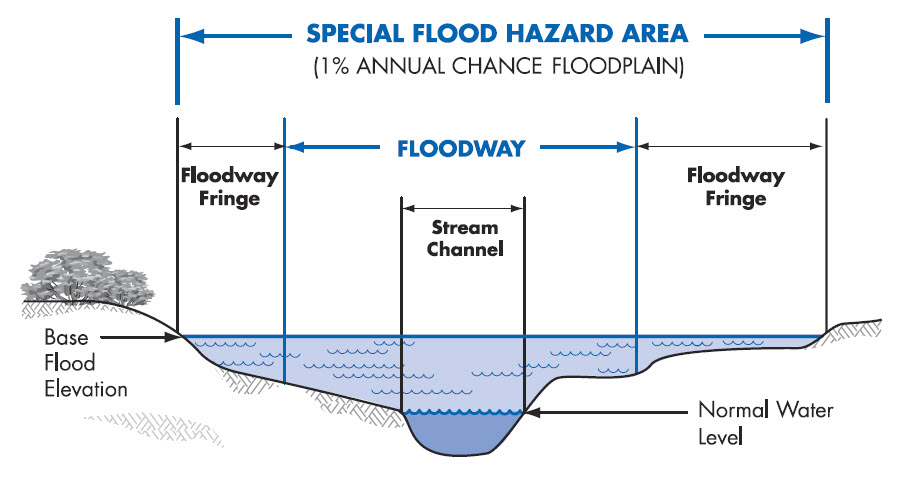
Heavy rains cause overtopping, which is by far the most common cause of dam failures. Dam spillways and structures are typically not designed for more than a 1-percent chance (aka 100-year) storm event. When a rain event exceeds this, the water starts to travel outside of the control spillway. This causes erosion of the soil on the dam from the excessive amount of water traveling over it. It is also possible for overtopping to occur from smaller rain events because of debris blockage of the outlet structure or spillways or because of settlement of the dam crest.

Foundation defects, including settlement and slope instability, cause about 30% of all dam failures.

Seepage or Piping causes the remaining 20% of the U.S. dam failures. Piping is the internal erosion caused by seepage under and through the dam. This usually happens around structures such as pipes through the dam and spillways. Seepage can also be caused by animals, like beavers, muskrats, groundhogs, and other rodents, burrowing in the dam, by roots of trees growing on the dam, and through cracks in the dam.  All earth dams have seepage resulting from water permeating slowly through the dam and its foundation. But this seepage must be controlled or it will progressively erode soil from the embankment or its foundation, resulting in rapid failure of the dam.>

What Should You Do To Protect Home?

Since the failure of a dam causes flood, your best option is to avoid building in a flood zone, unless you elevate and reinforce your home. Have your area surveyed and investigated for dam failure and flood determination so you’ll know if your dream house is safe to be constructed in that certain area.

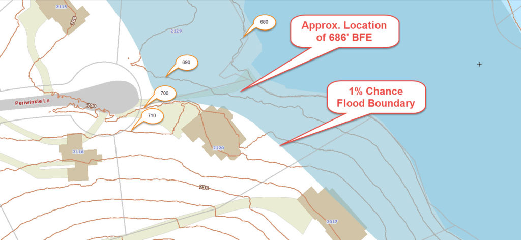
Do you live downstream from a dam? Is the dam a high-hazard or significant-hazard potential dam? To find out, contact your state or county emergency management agency and/or visit the National Inventory of Dams. There are around 2,228 dams on the National Inventory in Florida. And among those, 636 are listed as high or significant hazard potential dams.

If you live downstream from one of these dams, find out who owns and regulates the dam. This information should also be available from the National Inventory of Dams.>

Next, find out if there is an Emergency Action Plan in place. Again, consult your state or county emergency management agency. (Florida Emergency Management Agency)

Strangely enough, Florida is the only state in the United States that has not passed dam safety legislation.
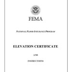
Posted in flood damage, flood survey, land surveyor | Tagged dam failure, flood, flood survey, flooding
Get Quote Button

The owner of this website, USA Surveying & Engineering, LLC., provides coordination of professional land surveying and engineering services in all 50 states. The professional surveying and engineering services provided to you will be conducted by fully licensed professionals in your state.

↑