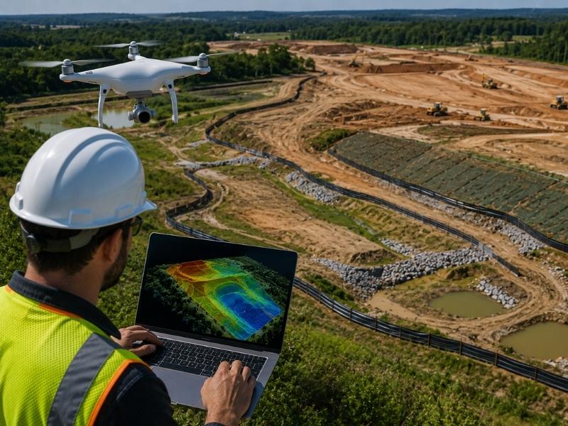
↓
 

Miami Land Surveying

Local Land Surveyors in Miami, FL

Miami Florida Land Surveying
(305) 376-7707
Miami Land Surveying
  • Home
  • ALTA Survey
  • Boundary Surveying
  • Construction Survey
  • Drone LiDAR Mapping
  • Elevation Certificate
  • Land Surveying
  • Topographic Survey
  • About Us
  • Blog
  • Contact Us
Home 1 2 3 … 12 13 >>

Post navigation

← Older posts

Welcome to Miami Land Surveying

Miami Land Surveying Posted on August 18, 2019 by MiamiLSSeptember 3, 2025

This site is intended to provide you with information on Land Surveying in Miami, FL and the surrounding Miami-Dade County area of Florida. If you’re looking for a Miami Land Surveyor, you’ve come to the right place. If you’d rather talk to someone about your land surveying needs, please call our local number at (305) 376-7707 today. For more information, please continue to read.

land surveyingLand Surveyors are professionals who make precise measurements to determine the size and boundaries of a piece of real estate.  While this is a simplistic definition, boundary surveying is one of the most common types of surveying related to home and land owners. If you fall into the following categories, please click on the appropriate link for more information on that subject:

Miami Land Surveying services:

    1. I need to know where my property corners or property lines are. (Boundary Survey)
    2. I have a loan closing or re-finance coming up on my home in a subdivision. (Lot Survey)
    3. I need a map of my property with contour lines to show elevation differences for my architect or engineer. (Topo Survey)
    4. I’ve just been told I’m in a flood zone or I’ve been told I need an elevation certificate in order to obtain flood insurance or prove I don’t need it. (Flood Survey)
    5. I’m purchasing a lot/house in a recorded subdivision. (Lot Survey – See Boundary Survey if you’re not in a subdivision.)
    6. I’m purchasing a larger tract of land, acreage, that hasn’t been subdivided in the past. (Boundary Survey)

Contact Miami Land Surveying services TODAY at (305) 376-7707.

Posted in boundary surveying, elevation certificate, land surveying, land surveyor | Tagged boundary survey, land surveyor, land surveyor miami tn, Miami Land Surveying

What Documents Does a Local Surveyor Review Before Starting?

Miami Land Surveying Posted on June 26, 2026 by MiamiLSJune 23, 2026
Local surveyor reviewing title documents, plat maps, and survey records before beginning field measurements on a property.

Use up and down arrow keys to resize the meta box pane.

Use up and down arrow keys to resize the meta box pane.

Most people think a survey starts when a crew shows up with equipment. It doesn’t. The real work begins at a desk, with records. A local surveyor reviews a stack of documents before setting foot on a property. Those documents shape every decision made in the field. In Miami, where older subdivisions, drainage easements and county records all interact, the document review is what separates an accurate survey from one that misses something important. This article explains exactly what gets reviewed and why it matters.

Use up and down arrow keys to resize the meta box pane.

Why Deeds and Legal Descriptions Come First

The deed is the starting point. It contains the legal description of the property, which is the written record of where the boundaries are supposed to be.

A legal description can take different forms. Some use metes and bounds, which describe the boundary as a series of directions and distances. Others reference a recorded plat, using lot and block numbers from a subdivision map. Both types tell the surveyor where to look for the property corners.

The problem is that legal descriptions are sometimes outdated, poorly written or in conflict with neighboring deeds. A description written 50 years ago may reference a monument that no longer exists. Two adjacent deeds may overlap slightly, creating a conflict the surveyor has to resolve.

Reading the deed carefully before fieldwork begins tells the surveyor what to expect on the ground. It also flags potential issues before they become costly surprises.

How Previous Surveys and Plat Maps Build the Property History

A deed tells you what the boundaries are supposed to be. An old survey shows you what a previous surveyor found when they went to locate them.

Previous surveys are valuable because they document where monuments were placed, what measurements were taken and how the boundary was interpreted at the time. If the current survey finds something different from what the old one shows, that difference has to be explained. It might mean a monument was disturbed. It might mean the earlier survey had an error. Either way, the comparison is useful.

Subdivision plat maps are equally important. In Miami, most residential lots are part of a recorded subdivision. The plat is the official map that established the lot dimensions, street widths and public areas when the subdivision was created. The local surveyor uses the plat to understand the original layout of the area and to find the monuments set when the subdivision was recorded.

When current field conditions don’t match the plat, the surveyor has to investigate why. Reviewing the plat before fieldwork starts means the surveyor already knows what to look for.

Easements, Rights of Way and Recorded Restrictions

A property boundary tells you where the land ends. It doesn’t tell you what can be done with all of it.

Easements are recorded rights that allow someone else to use a portion of the property. Utility easements let companies access underground lines. Drainage easements protect stormwater paths. Access easements may give a neighboring property the right to cross the lot.

Rights of way are similar. They reserve strips of land for roads, sidewalks or utilities. In some cases, a right of way runs along the front of a property and reduces the actual buildable area even though the owner holds title to that strip.

A local surveyor reviews title commitments, recorded easement documents and right of way plats before fieldwork begins. Those records show exactly where restrictions sit and how wide they are. That information affects where improvements can be placed and what gets shown on the final survey drawing.

Skipping this step leads to surveys that miss restrictions entirely. A developer who builds over an easement finds out during permit review or after construction starts, and neither timing is good.

Permit Records and Site Plans That Show Past Improvements

Properties change over time. Additions get built. Fences go up. Retaining walls get installed. Driveways get extended. Not all of those changes are permitted, and not all permitted changes match what was actually built.

A local surveyor reviews building permits, site plans and development records before fieldwork to understand what improvements are supposed to exist on the property. That information helps the surveyor identify features during the field visit and flag anything that doesn’t match the record.

In Miami, permit records are available through the city’s building department. Reviewing them before the survey starts gives the surveyor a baseline for what to expect. If a permit shows a fence was approved at a specific location but the fence in the field is three feet off from where it was supposed to go, that’s a discrepancy worth noting on the final drawing.

Retaining walls and utility connections are especially important. These features often affect drainage and grading. Knowing they exist before fieldwork starts means the surveyor can measure and document them properly rather than discovering them mid-survey.

Why County GIS Maps Are Only Part of the Story

County GIS maps, tax records and online parcel databases are useful tools. They give a quick overview of lot dimensions, addresses and ownership history. Many developers and homeowners check these resources before calling a surveyor.

The problem is that these tools were never designed to replace a professional survey. GIS data is compiled from recorded documents and aerial imagery, but it’s not survey-accurate. Parcel boundaries shown on a county map can be off by several feet. Property lines near canals, roads or subdivision boundaries are especially prone to misrepresentation in GIS data.

A local surveyor uses GIS maps and public records as background information. They provide context. They help the surveyor understand the general layout of an area before fieldwork starts. But the actual boundary positions are determined by field measurements tied to recorded plats and legal descriptions, not by what appears on a county parcel map.

Relying on GIS data alone to make building or permitting decisions is a shortcut that frequently causes problems. The county maps are helpful. They’re just not a survey.

Frequently Asked Questions

What documents does a local surveyor need before starting a survey?

A local surveyor typically reviews the deed, legal description, previous surveys, plat maps, easement records, and other public documents related to the property.

Why are previous surveys important?

Previous surveys provide historical information about boundaries, monuments, and improvements that can help identify discrepancies or changes over time.

Does a local surveyor review title documents?

Yes. Surveyors often review title commitments, easements, rights of way, and other recorded documents that may affect property use and ownership.

Are county GIS maps accurate enough for a survey?

No. GIS maps are useful reference tools, but they are not considered legal boundary documents and should not replace a professional survey.

Can missing or outdated records delay a survey?

Yes. Incomplete legal descriptions, missing plats, or conflicting records may require additional research before the surveyor can accurately establish property boundaries.

Posted in land surveying | Tagged land survey, Land Surveying, land surveying miami, land surveyor, land surveyor miami

How a Lot Survey Helps Prevent Setback Problems

Miami Land Surveying Posted on June 25, 2026 by MiamiLSJune 24, 2026

Building too close to a property line is one of the most common and costly mistakes in construction. It triggers stop-work orders, rejected permits and forced demolitions. A lot survey done before any project starts gives builders the exact boundary data they need to stay within legal limits. In Miami, where lot sizes vary and older subdivisions are common, skipping this step is a risk most projects can’t afford.

Why Property Setbacks Matter Before Any Building Project

A setback is the minimum distance a structure must sit from a property line. Cities set these rules to control how close buildings can get to streets, neighbors and public spaces.

Miami-Dade County enforces setback rules for almost every type of improvement. Additions, garages, fences, sheds, pools and driveways all have minimum distance rules. Those rules vary by zoning district. A setback that applies in one neighborhood may be different two blocks away.

Setback violations have real consequences. A structure built too close to the line can be ordered to stop mid-construction. In serious cases, a finished structure can be required to be removed or changed at the owner’s expense.

The time to find out where the setbacks apply is before work starts. A lot survey gives you the boundary data that makes that possible.

How a Lot Survey Confirms the True Property Lines

Most property owners think they know where their lines are. They’re often wrong.

Old fences, landscaping edges and assumed boundaries are not legal property lines. They’re habits. A lot survey establishes the actual legal boundaries of a parcel. A licensed surveyor finds the original survey monuments, researches the recorded plat and places markers at the true corners of the lot. The drawing that results shows the exact size and shape of the parcel.

That accuracy matters for setback compliance. A structure designed five feet from what the owner thinks is the line may actually be three feet from the real line. In a zoning district that requires a five-foot setback, that’s a violation.

In Miami, many residential lots were platted decades ago. Monuments may be buried or missing. Neighboring fences may have been placed without any survey reference. A current lot survey cuts through all of that. It gives the designer a reliable starting point.

Hidden Encroachments That Can Create Setback Violations

Setback problems don’t always come from new construction. They can already exist on the site before a single permit is filed.

Older properties often have driveways, patios, sheds and retaining walls that were built without permits or without checking setback rules. Those improvements may sit close to or directly on the property line. When a new permit application is filed, city reviewers check the site plan against current setback rules. Existing violations can surface during that review. They can delay or block the new project.

A lot survey documents existing conditions on the parcel. It shows where current improvements sit relative to the legal boundaries. If a shed is already within the setback zone, the developer knows that before submitting plans. That allows for an early decision: remove the structure, seek a variance or adjust the new project design.

Finding these issues before permit submission is far less painful than finding them during review.

Why Older Lots and Irregular Parcels Need Extra Attention

Standard rectangular lots in newer areas are fairly simple. Older lots in Miami present more challenges.

Corner lots have two front setbacks instead of one. That cuts the buildable area down. An owner who plans a garage addition without knowing the corner lot setback rules may find there’s no legal place to build it.

Oddly shaped parcels, flag lots and lots with curved frontages create irregular setback zones. The buildable area on these lots is hard to figure out without survey data. It has to be calculated from accurate boundary measurements.

Older Miami subdivisions also sometimes have lot lines that don’t match what’s shown on basic county maps. Lot splits, replatting and boundary changes over the decades can leave the recorded data out of step with what’s actually on the ground. A lot survey fixes that by working from primary survey records, not just county map data.

Architects and contractors who design projects on these lots without a current survey often produce drawings that don’t fit within the actual buildable area. That sends the plans back for revision. Revisions cost time and money.

Using Lot Survey Data to Avoid Permit Delays and Redesigns

Permit reviewers in Miami-Dade check dimensions. When a site plan is submitted, reviewers measure the proposed structure’s distance from the property lines shown on the plan. If those lines are wrong, the setback math is wrong and the plan gets rejected.

A lot survey gives the design team verified boundary data before the plans are drawn. The architect knows exactly where the property lines are. The contractor knows how close they can build. The permit application reflects accurate numbers.

That accuracy reduces the chance of a first-submission rejection. It also reduces the risk of a stop-work order during construction. Stop-work orders happen when a field inspector finds a structure being built in the wrong spot.

Stop-work orders are expensive. They delay trades, disrupt financing and sometimes require partial demolition. A lot survey that costs a few hundred to a few thousand dollars at the start is a small price compared to what a stop-work order can cost mid-construction.

Frequently Asked Questions

What Is a Lot Survey and Why Is It Needed Before Construction?

A lot survey identifies the legal boundaries of a parcel. A licensed surveyor locates original monuments and prepares a scaled drawing of the property. This information gives builders the accurate boundary data needed to design structures that comply with setback requirements before permits are submitted.

How Do Setback Violations Happen on Planned Projects?

Most setback violations occur because a design was based on assumed property lines. Old fences and visual estimates are often inaccurate and can be off by several feet. When the true legal boundary lies farther inward than expected, a proposed structure may end up violating setback requirements.

Can Existing Improvements Cause Setback Problems for a New Permit?

Yes. Sheds, patios, and driveways that were built without permits may already violate setback rules. A new permit application can trigger a review of these existing conditions. A lot survey reveals what is already on the property before plans are submitted.

Why Do Corner Lots and Older Parcels Require More Careful Survey Work?

Corner lots often have two front setbacks, which reduces the amount of buildable area. Older parcels may have been divided or replatted over time in ways that do not match county map data. A current lot survey resolves these issues by relying on primary survey records rather than assumptions.

How Does a Lot Survey Reduce Permit Rejections and Redesigns?

A lot survey provides the design team with verified boundary information before plans are prepared. Accurate property lines lead to accurate setback calculations, which helps reduce first-submission permit rejections and lowers the risk of stop-work orders caused by placement errors discovered during construction.

Posted in boundary surveying | Tagged lot survey

What a Commercial Property Surveyor Checks Before Redevelopment Starts

Miami Land Surveying Posted on June 24, 2026 by MiamiLSJune 23, 2026
Commercial property surveyors using surveying equipment to document existing site conditions before redevelopment of a commercial property.

A redevelopment project can look simple from the outside. The building is old. The lot is large. The zoning works. Then a commercial property survey comes back with problems. An access easement cuts through the planned parking area. A retaining wall sits six inches over the property line. A drainage swale doesn’t show up on any old site plans. In Miami, older commercial properties carry decades of informal changes. Surprises are common. This article covers what a commercial property surveyor checks before work begins.

Existing Easements and Access Rights That Can Limit Redevelopment

Easements are recorded legal rights. They let someone else use part of your property. Utility easements let utility companies reach underground lines. Access easements may give a neighbor the right to cross your lot. Drainage easements protect stormwater systems that serve more than one parcel.

Easements don’t go away when a property changes hands. They stay with the land. A developer who buys a site without knowing where easements are may plan a building directly over a recorded utility corridor. The utility company won’t allow that. The permit office won’t approve the plans until the conflict is resolved. That means a redesign. Redesigns cost money.

A commercial property surveyor finds every recorded easement on the parcel. The surveyor maps each one onto the site. You can see exactly where the restrictions are before the design starts. The design team works around them early, not after the permit application is already in review.

Older commercial properties also carry shared parking and access agreements. These don’t always show up in a basic title summary. A surveyor who pulls the full chain of recorded documents gives the developer a clear picture before any commitments are made.

Boundary Line Conflicts Hidden by Older Improvements

Older commercial properties often have fences, walls and paving that were built without a survey. Over time, those improvements drift. A shared fence gets replaced slightly off its original spot. A curb gets poured past the legal boundary. A neighboring building gets expanded close to the line.

None of this shows up in a visual check. It only shows up when a surveyor compares the physical location of those improvements against the legal boundary.

This matters for redevelopment. The approved site plan must reflect the true legal property lines. If a wall on the next parcel sits inside your boundary, that changes how close you can build. If your own pavement extends past the line onto a neighboring lot, it has to be fixed before permits are issued.

In Miami’s older commercial areas, boundary conflicts are more common than most developers expect. Finding them before the design is done avoids the cost of revising plans after the permit review reveals the problem.

Site Features That Affect Demolition and New Construction

Before a commercial site can be redeveloped, someone needs to know what’s on it. That sounds simple. In practice, many commercial sites have underground structures, old drainage systems and utility connections that aren’t in any available record.

A commercial property surveyor documents all visible above-ground improvements. Buildings, canopies, paving, curbing, signage, utility structures, fencing and drainage inlets all get located and measured. That information feeds directly into the demolition scope and the new construction plans.

It also prevents costly surprises during demolition. A contractor who doesn’t know where an old vault or a buried utility line sits will find out during excavation. At that point, the discovery delays the project and changes the budget.

The survey creates a record of existing conditions. When the design team draws the new site plan over that record, they work with real data, not guesses.

Elevation Changes and Drainage Conditions That Affect Redevelopment Plans

Miami is flat. But flat doesn’t mean uniform. Commercial sites have grade changes that affect how water moves. Low spots collect runoff. Drainage structures direct flow toward outfall points. Pavement grades control whether water moves toward buildings or away from them.

A commercial property surveyor measures existing ground elevations. The surveyor also documents drainage features across the site. That information is essential for the engineer designing the new grading and stormwater system.

Miami-Dade County has post-construction stormwater rules for commercial redevelopment. The engineer must show the new site handles runoff correctly. That analysis starts with knowing what the existing conditions are. A survey that captures current grades, drainage inlets and outfall connections gives the engineer real numbers to work from.

Without that data, the stormwater design is built on guesses. Wrong guesses generate plan revisions. Plan revisions delay permits and push the construction start date back.

Encroachments and Setback Issues That Can Delay Approvals

An encroachment happens when a structure sits on land it doesn’t belong to. A wall that crosses the property line onto a neighbor’s parcel is an encroachment. So is a canopy that extends into a public right-of-way without a permit.

Setback violations happen when a structure sits too close to a property line. On older Miami commercial sites, some structures were legal under old rules. They may not meet current requirements. When a redevelopment permit is filed, reviewers check the survey against current setback standards.

If the existing building has a setback violation, the city may require the new project to fix it before the permit is approved. That can change the project scope and the budget.

Finding encroachments and setback conflicts before the design is drawn gives the developer options. Those options include negotiating with the neighbor, redesigning to avoid the conflict or adjusting the project scope. All of those conversations are far less expensive before the permit application goes in.

Frequently Asked Questions

What Does a Commercial Property Surveyor Do Before Redevelopment Starts?

A commercial property surveyor verifies property boundaries, documents existing site conditions, identifies recorded easements, and gathers the information engineers and architects need to prepare redevelopment plans accurately.

Why Is a Survey Needed Before Redeveloping Commercial Property?

A survey helps uncover hidden restrictions, boundary conflicts, drainage concerns, and encroachments. If these issues are discovered late in the process, they can delay permits and increase construction costs.

Can a Commercial Property Surveyor Find Easements on a Property?

Yes. A commercial property surveyor locates recorded easements and maps them onto the site. This allows the design team to understand where building restrictions apply before plans are finalized.

When Should a Commercial Property Survey Be Ordered?

A commercial property survey should be ordered during the due diligence stage, before architects and engineers complete the redevelopment plans. Identifying problems early helps keep the project on schedule and reduces the risk of costly revisions.

Can Boundary Problems Delay a Commercial Redevelopment Project?

Yes. Encroachments, setback violations, and conflicting property lines can require redesigns and additional review. When these issues are discovered late, they can delay approvals and significantly increase project costs.

Posted in land surveying | Tagged land survey, Land Surveying

Post navigation

← Older posts
Get Quote Button

Select Your City

  • Aventura
  • Coral Gables
  • Cutler Bay
  • Doral
  • Hialeah
  • Homestead
  • Miami Beach
  • Miami Gardens
  • Miami Lakes
  • North Miami
  • North Miami Beach

The owner of this website, USA Surveying & Engineering, LLC., provides coordination of professional land surveying and engineering services in all 50 states. The professional surveying and engineering services provided to you will be conducted by fully licensed professionals in your state.

Privacy Policy | Terms of Use
↑