
Building too close to a property line is one of the most common and costly mistakes in construction. It triggers stop-work orders, rejected permits and forced demolitions. A lot survey done before any project starts gives builders the exact boundary data they need to stay within legal limits. In Miami, where lot sizes vary and older subdivisions are common, skipping this step is a risk most projects can’t afford.
Why Property Setbacks Matter Before Any Building Project
A setback is the minimum distance a structure must sit from a property line. Cities set these rules to control how close buildings can get to streets, neighbors and public spaces.
Miami-Dade County enforces setback rules for almost every type of improvement. Additions, garages, fences, sheds, pools and driveways all have minimum distance rules. Those rules vary by zoning district. A setback that applies in one neighborhood may be different two blocks away.
Setback violations have real consequences. A structure built too close to the line can be ordered to stop mid-construction. In serious cases, a finished structure can be required to be removed or changed at the owner’s expense.
The time to find out where the setbacks apply is before work starts. A lot survey gives you the boundary data that makes that possible.
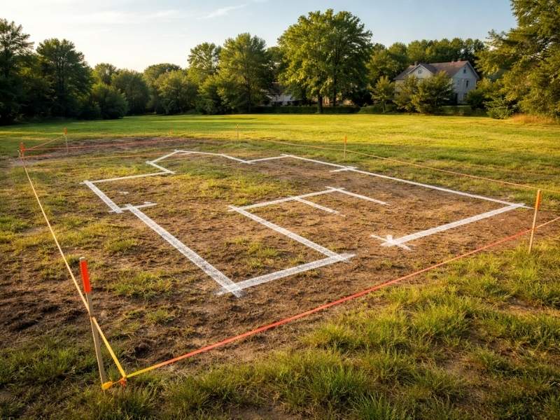
How a Lot Survey Confirms the True Property Lines
Most property owners think they know where their lines are. They’re often wrong.
Old fences, landscaping edges and assumed boundaries are not legal property lines. They’re habits. A lot survey establishes the actual legal boundaries of a parcel. A licensed surveyor finds the original survey monuments, researches the recorded plat and places markers at the true corners of the lot. The drawing that results shows the exact size and shape of the parcel.
That accuracy matters for setback compliance. A structure designed five feet from what the owner thinks is the line may actually be three feet from the real line. In a zoning district that requires a five-foot setback, that’s a violation.
In Miami, many residential lots were platted decades ago. Monuments may be buried or missing. Neighboring fences may have been placed without any survey reference. A current lot survey cuts through all of that. It gives the designer a reliable starting point.
Hidden Encroachments That Can Create Setback Violations
Setback problems don’t always come from new construction. They can already exist on the site before a single permit is filed.
Older properties often have driveways, patios, sheds and retaining walls that were built without permits or without checking setback rules. Those improvements may sit close to or directly on the property line. When a new permit application is filed, city reviewers check the site plan against current setback rules. Existing violations can surface during that review. They can delay or block the new project.
A lot survey documents existing conditions on the parcel. It shows where current improvements sit relative to the legal boundaries. If a shed is already within the setback zone, the developer knows that before submitting plans. That allows for an early decision: remove the structure, seek a variance or adjust the new project design.
Finding these issues before permit submission is far less painful than finding them during review.
Why Older Lots and Irregular Parcels Need Extra Attention
Standard rectangular lots in newer areas are fairly simple. Older lots in Miami present more challenges.
Corner lots have two front setbacks instead of one. That cuts the buildable area down. An owner who plans a garage addition without knowing the corner lot setback rules may find there’s no legal place to build it.
Oddly shaped parcels, flag lots and lots with curved frontages create irregular setback zones. The buildable area on these lots is hard to figure out without survey data. It has to be calculated from accurate boundary measurements.
Older Miami subdivisions also sometimes have lot lines that don’t match what’s shown on basic county maps. Lot splits, replatting and boundary changes over the decades can leave the recorded data out of step with what’s actually on the ground. A lot survey fixes that by working from primary survey records, not just county map data.
Architects and contractors who design projects on these lots without a current survey often produce drawings that don’t fit within the actual buildable area. That sends the plans back for revision. Revisions cost time and money.
Using Lot Survey Data to Avoid Permit Delays and Redesigns
Permit reviewers in Miami-Dade check dimensions. When a site plan is submitted, reviewers measure the proposed structure’s distance from the property lines shown on the plan. If those lines are wrong, the setback math is wrong and the plan gets rejected.
A lot survey gives the design team verified boundary data before the plans are drawn. The architect knows exactly where the property lines are. The contractor knows how close they can build. The permit application reflects accurate numbers.
That accuracy reduces the chance of a first-submission rejection. It also reduces the risk of a stop-work order during construction. Stop-work orders happen when a field inspector finds a structure being built in the wrong spot.
Stop-work orders are expensive. They delay trades, disrupt financing and sometimes require partial demolition. A lot survey that costs a few hundred to a few thousand dollars at the start is a small price compared to what a stop-work order can cost mid-construction.
Frequently Asked Questions
What Is a Lot Survey and Why Is It Needed Before Construction?
A lot survey identifies the legal boundaries of a parcel. A licensed surveyor locates original monuments and prepares a scaled drawing of the property. This information gives builders the accurate boundary data needed to design structures that comply with setback requirements before permits are submitted.
How Do Setback Violations Happen on Planned Projects?
Most setback violations occur because a design was based on assumed property lines. Old fences and visual estimates are often inaccurate and can be off by several feet. When the true legal boundary lies farther inward than expected, a proposed structure may end up violating setback requirements.
Can Existing Improvements Cause Setback Problems for a New Permit?
Yes. Sheds, patios, and driveways that were built without permits may already violate setback rules. A new permit application can trigger a review of these existing conditions. A lot survey reveals what is already on the property before plans are submitted.
Why Do Corner Lots and Older Parcels Require More Careful Survey Work?
Corner lots often have two front setbacks, which reduces the amount of buildable area. Older parcels may have been divided or replatted over time in ways that do not match county map data. A current lot survey resolves these issues by relying on primary survey records rather than assumptions.
How Does a Lot Survey Reduce Permit Rejections and Redesigns?
A lot survey provides the design team with verified boundary information before plans are prepared. Accurate property lines lead to accurate setback calculations, which helps reduce first-submission permit rejections and lowers the risk of stop-work orders caused by placement errors discovered during construction.