↓
 

Miami Land Surveying

Local Land Surveyors in Miami, FL

Miami Florida Land Surveying
(305) 376-7707
Miami Land Surveying
  • Home
  • ALTA Survey
  • Boundary Surveying
  • Construction Survey
  • Drone LiDAR Mapping
  • Elevation Certificate
  • Land Surveying
  • Topographic Survey
  • About Us
  • Blog
  • Contact Us
Home→Tags land surveyor miami 1 2 >>

Tag Archives: land surveyor miami

Post navigation

← Older posts

What Documents Does a Local Surveyor Review Before Starting?

Miami Land Surveying Posted on June 26, 2026 by MiamiLSJune 23, 2026
Local surveyor reviewing title documents, plat maps, and survey records before beginning field measurements on a property.

Use up and down arrow keys to resize the meta box pane.

Use up and down arrow keys to resize the meta box pane.

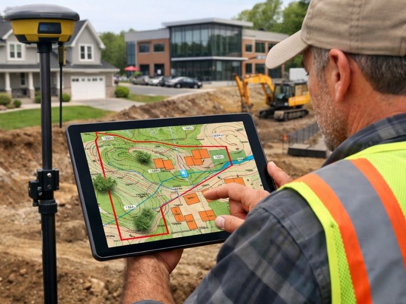
Most people think a survey starts when a crew shows up with equipment. It doesn’t. The real work begins at a desk, with records. A local surveyor reviews a stack of documents before setting foot on a property. Those documents shape every decision made in the field. In Miami, where older subdivisions, drainage easements and county records all interact, the document review is what separates an accurate survey from one that misses something important. This article explains exactly what gets reviewed and why it matters.

Use up and down arrow keys to resize the meta box pane.

Why Deeds and Legal Descriptions Come First

The deed is the starting point. It contains the legal description of the property, which is the written record of where the boundaries are supposed to be.

A legal description can take different forms. Some use metes and bounds, which describe the boundary as a series of directions and distances. Others reference a recorded plat, using lot and block numbers from a subdivision map. Both types tell the surveyor where to look for the property corners.

The problem is that legal descriptions are sometimes outdated, poorly written or in conflict with neighboring deeds. A description written 50 years ago may reference a monument that no longer exists. Two adjacent deeds may overlap slightly, creating a conflict the surveyor has to resolve.

Reading the deed carefully before fieldwork begins tells the surveyor what to expect on the ground. It also flags potential issues before they become costly surprises.

How Previous Surveys and Plat Maps Build the Property History

A deed tells you what the boundaries are supposed to be. An old survey shows you what a previous surveyor found when they went to locate them.

Previous surveys are valuable because they document where monuments were placed, what measurements were taken and how the boundary was interpreted at the time. If the current survey finds something different from what the old one shows, that difference has to be explained. It might mean a monument was disturbed. It might mean the earlier survey had an error. Either way, the comparison is useful.

Subdivision plat maps are equally important. In Miami, most residential lots are part of a recorded subdivision. The plat is the official map that established the lot dimensions, street widths and public areas when the subdivision was created. The local surveyor uses the plat to understand the original layout of the area and to find the monuments set when the subdivision was recorded.

When current field conditions don’t match the plat, the surveyor has to investigate why. Reviewing the plat before fieldwork starts means the surveyor already knows what to look for.

Easements, Rights of Way and Recorded Restrictions

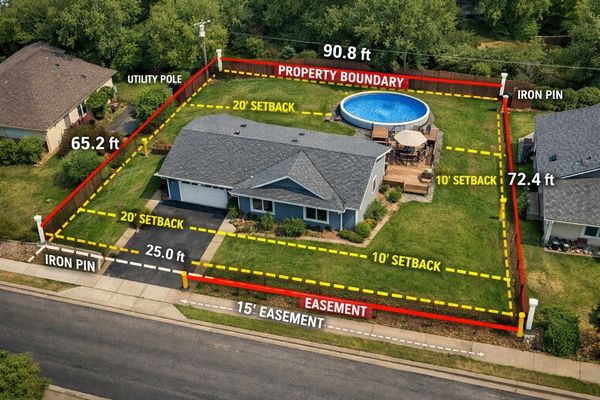
A property boundary tells you where the land ends. It doesn’t tell you what can be done with all of it.

Easements are recorded rights that allow someone else to use a portion of the property. Utility easements let companies access underground lines. Drainage easements protect stormwater paths. Access easements may give a neighboring property the right to cross the lot.

Rights of way are similar. They reserve strips of land for roads, sidewalks or utilities. In some cases, a right of way runs along the front of a property and reduces the actual buildable area even though the owner holds title to that strip.

A local surveyor reviews title commitments, recorded easement documents and right of way plats before fieldwork begins. Those records show exactly where restrictions sit and how wide they are. That information affects where improvements can be placed and what gets shown on the final survey drawing.

Skipping this step leads to surveys that miss restrictions entirely. A developer who builds over an easement finds out during permit review or after construction starts, and neither timing is good.

Permit Records and Site Plans That Show Past Improvements

Properties change over time. Additions get built. Fences go up. Retaining walls get installed. Driveways get extended. Not all of those changes are permitted, and not all permitted changes match what was actually built.

A local surveyor reviews building permits, site plans and development records before fieldwork to understand what improvements are supposed to exist on the property. That information helps the surveyor identify features during the field visit and flag anything that doesn’t match the record.

In Miami, permit records are available through the city’s building department. Reviewing them before the survey starts gives the surveyor a baseline for what to expect. If a permit shows a fence was approved at a specific location but the fence in the field is three feet off from where it was supposed to go, that’s a discrepancy worth noting on the final drawing.

Retaining walls and utility connections are especially important. These features often affect drainage and grading. Knowing they exist before fieldwork starts means the surveyor can measure and document them properly rather than discovering them mid-survey.

Why County GIS Maps Are Only Part of the Story

County GIS maps, tax records and online parcel databases are useful tools. They give a quick overview of lot dimensions, addresses and ownership history. Many developers and homeowners check these resources before calling a surveyor.

The problem is that these tools were never designed to replace a professional survey. GIS data is compiled from recorded documents and aerial imagery, but it’s not survey-accurate. Parcel boundaries shown on a county map can be off by several feet. Property lines near canals, roads or subdivision boundaries are especially prone to misrepresentation in GIS data.

A local surveyor uses GIS maps and public records as background information. They provide context. They help the surveyor understand the general layout of an area before fieldwork starts. But the actual boundary positions are determined by field measurements tied to recorded plats and legal descriptions, not by what appears on a county parcel map.

Relying on GIS data alone to make building or permitting decisions is a shortcut that frequently causes problems. The county maps are helpful. They’re just not a survey.

Frequently Asked Questions

What documents does a local surveyor need before starting a survey?

A local surveyor typically reviews the deed, legal description, previous surveys, plat maps, easement records, and other public documents related to the property.

Why are previous surveys important?

Previous surveys provide historical information about boundaries, monuments, and improvements that can help identify discrepancies or changes over time.

Does a local surveyor review title documents?

Yes. Surveyors often review title commitments, easements, rights of way, and other recorded documents that may affect property use and ownership.

Are county GIS maps accurate enough for a survey?

No. GIS maps are useful reference tools, but they are not considered legal boundary documents and should not replace a professional survey.

Can missing or outdated records delay a survey?

Yes. Incomplete legal descriptions, missing plats, or conflicting records may require additional research before the surveyor can accurately establish property boundaries.

Posted in land surveying | Tagged land survey, Land Surveying, land surveying miami, land surveyor, land surveyor miami

How a Metes and Bounds Survey Affects Your Deed

Miami Land Surveying Posted on June 3, 2026 by MiamiLSJune 2, 2026
Land surveying professional reviewing a property boundary map and legal land survey data on a construction site

A metes and bounds is the legal language that defines exactly where your property begins and ends. If your deed uses this system, a surveyor reads those written directions and turns them into physical markers on the ground. Get it wrong, and your transaction stalls, your title has gaps, or your boundary ends up in the wrong place.

What Is a Metes and Bounds Survey?

It’s a way of describing land using directions and distances. Instead of saying “Lot 5, Block 3,” a metes and bounds survey walks the boundary line step by step.

It starts at a fixed point called the Point of Beginning (POB). From there, it gives a bearing (a compass direction) and a distance. Then another. Then another. Until it loops back to where it started.

A simple example looks like this:

“Beginning at the iron pin at the northeast corner of the tract, thence South 45 degrees West, 200 feet, thence North 45 degrees West, 150 feet, thence North 45 degrees East, 200 feet, thence South 45 degrees East, 150 feet to the Point of Beginning.”

That’s it. No lot number. No plat map reference. Just directions and distances.

Where This System Shows Up

Metes and bounds surveys are common on:

  • Older properties recorded before subdivision plats existed
  • Irregular-shaped lots that don’t fit a standard grid
  • Waterfront and coastal parcels where boundaries follow natural features
  • Large tracts and acreage that were never formally subdivided
  • Properties split off from larger parcels by private agreement

If your deed reads like a set of walking directions, you’re looking at metes and bounds.

How It Affects Your Deed

Land surveying illustration showing property boundaries, setbacks, easements, and boundary monuments on a residential lot

The Survey Is the Legal Boundary

In a metes and bounds deed, the written survey controls everything. Not the fence. Not the neighbor’s claim. Not what the previous owner told you.

If the survey says the line runs 200 feet south, then 200 feet south is the legal boundary, regardless of where the old fence sits.

A licensed surveyor takes that written language and locates it physically on the ground. They research the chain of title, find existing monuments, measure distances and check them against the recorded deed. What they produce is the legal map of your property.

Errors in the Survey Create Real Problems

Metes and bounds surveys can have mistakes. Common ones include:

  • A typo in a bearing (South 45 degrees instead of South 54 degrees changes the line entirely)
  • A distance that doesn’t match existing monuments in the field
  • A survey that “fails to close,” meaning the boundary doesn’t return to the Point of Beginning

When a survey fails to close, it means the math doesn’t work out. The boundary lines don’t form a complete shape. That’s a defect in the deed, and it creates a legal problem that has to be fixed before a clean title can be issued.

Conflicts Between Calls

A metes and bounds survey has different types of calls. Monument calls refer to a physical object (an iron pin, a concrete marker, a tree). Distance calls give a measurement. Bearing calls give a direction.

When these conflict, there’s a legal order of priority:

  1. Natural monuments (rivers, rock formations)
  2. Artificial monuments (iron pins, concrete markers)
  3. Adjacent boundaries (neighboring deed lines)
  4. Distances
  5. Bearings
  6. Area

So if the deed says “thence to the iron pin” but the distance listed doesn’t reach the iron pin, the iron pin wins. The distance is secondary. A surveyor knows this hierarchy. A buyer relying on a county GIS map does not.

Why Developers Need to Pay Attention

Due Diligence Before You Buy

Before acquiring a parcel described by metes and bounds, you need a boundary survey. Not a tax parcel map. Not a GIS overlay. A field-verified survey by a licensed Professional Surveyor and Mapper.

The survey will confirm:

  • The survey actually closes
  • The bearings and distances match what’s on the ground
  • There are no gaps or overlaps with neighboring parcels
  • Monuments exist and are in the right locations

If the surveyor finds a problem, you know before you close, not after.

Title Insurance Won’t Always Cover Survey Defects

Title companies look hard at metes and bounds surveys before issuing a policy. If a survey is defective or the boundary has a gap, the title company may exclude that portion from coverage. That means the defect stays your problem even after closing.

A boundary survey submitted before closing gives the title company what it needs to issue a clean policy, or to flag the problem early enough to fix it.

Easements and Encroachments Are Harder to Spot

On a platted lot, easements are usually shown on the recorded plat. On a metes and bounds parcel, they may only exist in the deed language or in separate recorded instruments. A surveyor researches those documents and shows them on the survey map.

Without that step, you can buy a parcel not knowing a utility easement cuts through the middle of your planned building footprint.

What Happens When a Survey Is Defective

If a metes and bounds survey has an error, the options are:

  • Corrective deed: The grantor (seller or prior owner) signs a new deed correcting the error. This is the cleanest fix.
  • Boundary line agreement: Neighboring property owners agree in writing where the line sits. Both sign. Both record it.
  • Quiet title action: A court proceeding that legally establishes ownership and boundary when other methods fail. This is slow and expensive.

None of these are quick. All of them are cheaper to avoid by catching the problem before closing.

Frequently Asked Questions

What is a metes and bounds survey?

A metes and bounds survey is a field measurement performed by a licensed surveyor to locate and verify the boundary described in a metes and bounds deed. The surveyor researches the title chain, finds existing monuments, measures distances and bearings, and produces a certified map showing the legal boundary on the ground.

How do I know if my deed uses metes and bounds?

Open your deed and look at the legal survey. If it lists compass bearings (like “North 30 degrees East”), distances in feet, and references a Point of Beginning, it’s a metes and bounds survey. If it says “Lot 4, Block 2 of [Subdivision Name],” it uses the lot-and-block system instead.

What does it mean when a metes and bounds survey fails to close?

It means the boundary lines, when plotted, don’t return to the Point of Beginning. The shape doesn’t close. This is a defect in the deed. It has to be corrected before a title company will issue a clean policy or before a lender will approve a loan on the property.

Can a boundary survey fix a bad metes and bounds survey?

A survey identifies the problem. It doesn’t fix it on its own. The fix usually requires a corrective deed, a boundary line agreement with neighboring owners, or a court action. The survey gives you and your attorney the accurate information needed to pursue the right remedy.

Do I need a new survey if the property already has one on file?

It depends on how old the survey is and what has changed since it was done. If monuments have moved, if neighboring parcels have been split or reconfigured, or if the survey is more than a few years old, a new survey is usually required by lenders and title companies before closing.

Posted in land surveying | Tagged boundary survey, Land Surveying, land surveyor miami

Why ALTA Land Surveys Matter Before Construction Loans Close

Miami Land Surveying Posted on May 6, 2026 by MiamiLSMay 5, 2026
ALTA land survey context showing crane and high-rise buildings at a Miami construction site near the water
#image_title

Miami keeps building. New towers rise in Wynwood and Brickell. Cranes fill the skyline. 

From the street, it looks easy. Buy land, get a loan, start building.

That’s not how it works.

Before any money moves, lenders slow everything down. They check the land first. They check the risks. They want facts, not assumptions.

That’s where an ALTA land survey comes in.

Miami land is not simple

Banks do not approve construction loans based on plans alone. They want proof that the site works in real life.

Miami makes this harder.

Lots are tight. Old records do not always match the ground. Access points can be unclear. Some parcels have changed over time.

So lenders ask for one thing before closing. They want a full survey that shows the real condition of the land.

That survey is the ALTA land survey.

Why lenders require an ALTA land survey

A construction loan is a big risk for a bank. They are not guessing where buildings sit or where lines run.

They want proof.

An ALTA land survey gives that proof. It shows what is real, not just what is written in documents.

Without it, lenders hesitate. Deals slow down or stop.

What the ALTA land survey shows

This survey checks more than boundaries.

It lines up records with actual site conditions. That matters in a city like Miami where things shift over time.

It shows:

  • Property lines based on legal records
  • Buildings already on the site
  • Driveways and access points
  • Utility easements
  • Encroachments from nearby properties

This is not guesswork. It is a clear view of the land as it exists today.

That clarity helps lenders move forward.

Where projects run into trouble

Deals don’t fall apart for no reason. They usually hit the same types of issues.

A wall crosses a property line. A fence sits in the wrong spot. A utility line cuts through part of the lot.

These are common in Miami.

When the survey finds them late, everything pauses. Plans must change. Teams go back to fix the issue.

That costs time. It costs money. It can delay closing.

Why timing matters more than people think

Some teams treat the survey like a final step. That is a mistake.

If you order it late, problems show up when the project is already moving.

Designs may be finished. Contractors may be ready. Then the survey shows something off.

Now you adjust everything. That delay hurts.

Teams that order early catch issues sooner. They fix them before plans are locked in.

That keeps the project moving.

Miami makes ai small mistakes expensive

ALTA land survey equipment set up on construction site with cranes and structural framing in progress
#image_title

In Miami, space is tight.

Buildings sit close together. Lots don’t leave much room for error.

Add older records into the mix, and you get gaps between what is written and what exists.

Zoning rules and flood limits add more pressure.

A small mistake here can stop a project fast. That is why accuracy matters so much in this market.

Title companies rely on the same data

Lenders are not the only ones checking.

Title companies also review the property before closing. They compare legal records with what the survey shows.

If something does not match, they raise it right away.

That can delay the deal or add conditions before approval.

A clear ALTA land survey keeps this part clean.

What smart developers do 

Experienced developers do not wait.

They order the ALTA land survey early. They review it with their team. They fix issues before final plans.

They check where the real boundaries sit. They confirm access. They look for anything crossing into the lot.

This step avoids problems later.

Skipping it or delaying it usually leads to trouble.

Projects keep moving, but the process stays strict

Miami will keep growing. New projects will keep coming.

But behind every project, the same process holds.

Lenders check risk. Title companies check records. Surveyors confirm what is on the ground.

The ALTA land survey ties all of that together.

Handle it early, and the project moves forward.

Ignore it, and delays show up fast.

Posted in land surveying | Tagged alta land survey, Land Surveying, land surveyor miami

Post navigation

← Older posts
Get Quote Button

Select Your City

  • Aventura
  • Coral Gables
  • Cutler Bay
  • Doral
  • Hialeah
  • Homestead
  • Miami Beach
  • Miami Gardens
  • Miami Lakes
  • North Miami
  • North Miami Beach

The owner of this website, USA Surveying & Engineering, LLC., provides coordination of professional land surveying and engineering services in all 50 states. The professional surveying and engineering services provided to you will be conducted by fully licensed professionals in your state.

Privacy Policy | Terms of Use
↑