↓
 

Miami Land Surveying

Local Land Surveyors in Miami, FL

Miami Florida Land Surveying
(305) 376-7707
Miami Land Surveying
  • Home
  • ALTA Survey
  • Boundary Surveying
  • Construction Survey
  • Drone LiDAR Mapping
  • Elevation Certificate
  • Land Surveying
  • Topographic Survey
  • About Us
  • Blog
  • Contact Us
Home→Tags Land Surveying - Page 2 << 1 2 3 4 >>

Tag Archives: Land Surveying

Post navigation

← Older posts
Newer posts →

How a Metes and Bounds Survey Affects Your Deed

Miami Land Surveying Posted on June 3, 2026 by MiamiLSJune 2, 2026
Land surveying professional reviewing a property boundary map and legal land survey data on a construction site

A metes and bounds is the legal language that defines exactly where your property begins and ends. If your deed uses this system, a surveyor reads those written directions and turns them into physical markers on the ground. Get it wrong, and your transaction stalls, your title has gaps, or your boundary ends up in the wrong place.

What Is a Metes and Bounds Survey?

It’s a way of describing land using directions and distances. Instead of saying “Lot 5, Block 3,” a metes and bounds survey walks the boundary line step by step.

It starts at a fixed point called the Point of Beginning (POB). From there, it gives a bearing (a compass direction) and a distance. Then another. Then another. Until it loops back to where it started.

A simple example looks like this:

“Beginning at the iron pin at the northeast corner of the tract, thence South 45 degrees West, 200 feet, thence North 45 degrees West, 150 feet, thence North 45 degrees East, 200 feet, thence South 45 degrees East, 150 feet to the Point of Beginning.”

That’s it. No lot number. No plat map reference. Just directions and distances.

Where This System Shows Up

Metes and bounds surveys are common on:

  • Older properties recorded before subdivision plats existed
  • Irregular-shaped lots that don’t fit a standard grid
  • Waterfront and coastal parcels where boundaries follow natural features
  • Large tracts and acreage that were never formally subdivided
  • Properties split off from larger parcels by private agreement

If your deed reads like a set of walking directions, you’re looking at metes and bounds.

How It Affects Your Deed

Land surveying illustration showing property boundaries, setbacks, easements, and boundary monuments on a residential lot

The Survey Is the Legal Boundary

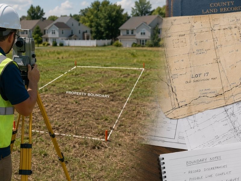
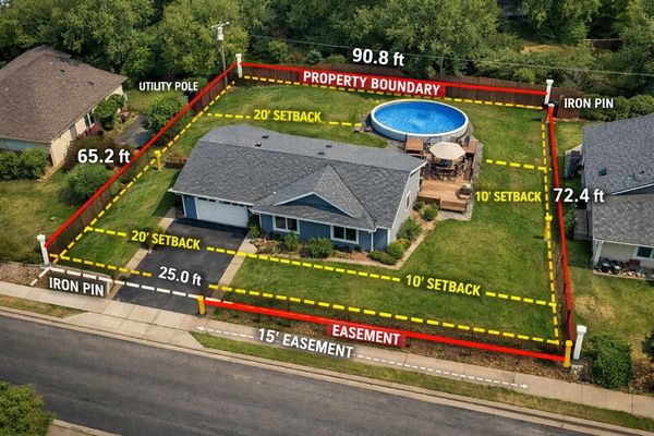
In a metes and bounds deed, the written survey controls everything. Not the fence. Not the neighbor’s claim. Not what the previous owner told you.

If the survey says the line runs 200 feet south, then 200 feet south is the legal boundary, regardless of where the old fence sits.

A licensed surveyor takes that written language and locates it physically on the ground. They research the chain of title, find existing monuments, measure distances and check them against the recorded deed. What they produce is the legal map of your property.

Errors in the Survey Create Real Problems

Metes and bounds surveys can have mistakes. Common ones include:

  • A typo in a bearing (South 45 degrees instead of South 54 degrees changes the line entirely)
  • A distance that doesn’t match existing monuments in the field
  • A survey that “fails to close,” meaning the boundary doesn’t return to the Point of Beginning

When a survey fails to close, it means the math doesn’t work out. The boundary lines don’t form a complete shape. That’s a defect in the deed, and it creates a legal problem that has to be fixed before a clean title can be issued.

Conflicts Between Calls

A metes and bounds survey has different types of calls. Monument calls refer to a physical object (an iron pin, a concrete marker, a tree). Distance calls give a measurement. Bearing calls give a direction.

When these conflict, there’s a legal order of priority:

  1. Natural monuments (rivers, rock formations)
  2. Artificial monuments (iron pins, concrete markers)
  3. Adjacent boundaries (neighboring deed lines)
  4. Distances
  5. Bearings
  6. Area

So if the deed says “thence to the iron pin” but the distance listed doesn’t reach the iron pin, the iron pin wins. The distance is secondary. A surveyor knows this hierarchy. A buyer relying on a county GIS map does not.

Why Developers Need to Pay Attention

Due Diligence Before You Buy

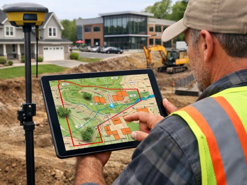
Before acquiring a parcel described by metes and bounds, you need a boundary survey. Not a tax parcel map. Not a GIS overlay. A field-verified survey by a licensed Professional Surveyor and Mapper.

The survey will confirm:

  • The survey actually closes
  • The bearings and distances match what’s on the ground
  • There are no gaps or overlaps with neighboring parcels
  • Monuments exist and are in the right locations

If the surveyor finds a problem, you know before you close, not after.

Title Insurance Won’t Always Cover Survey Defects

Title companies look hard at metes and bounds surveys before issuing a policy. If a survey is defective or the boundary has a gap, the title company may exclude that portion from coverage. That means the defect stays your problem even after closing.

A boundary survey submitted before closing gives the title company what it needs to issue a clean policy, or to flag the problem early enough to fix it.

Easements and Encroachments Are Harder to Spot

On a platted lot, easements are usually shown on the recorded plat. On a metes and bounds parcel, they may only exist in the deed language or in separate recorded instruments. A surveyor researches those documents and shows them on the survey map.

Without that step, you can buy a parcel not knowing a utility easement cuts through the middle of your planned building footprint.

What Happens When a Survey Is Defective

If a metes and bounds survey has an error, the options are:

  • Corrective deed: The grantor (seller or prior owner) signs a new deed correcting the error. This is the cleanest fix.
  • Boundary line agreement: Neighboring property owners agree in writing where the line sits. Both sign. Both record it.
  • Quiet title action: A court proceeding that legally establishes ownership and boundary when other methods fail. This is slow and expensive.

None of these are quick. All of them are cheaper to avoid by catching the problem before closing.

Frequently Asked Questions

What is a metes and bounds survey?

A metes and bounds survey is a field measurement performed by a licensed surveyor to locate and verify the boundary described in a metes and bounds deed. The surveyor researches the title chain, finds existing monuments, measures distances and bearings, and produces a certified map showing the legal boundary on the ground.

How do I know if my deed uses metes and bounds?

Open your deed and look at the legal survey. If it lists compass bearings (like “North 30 degrees East”), distances in feet, and references a Point of Beginning, it’s a metes and bounds survey. If it says “Lot 4, Block 2 of [Subdivision Name],” it uses the lot-and-block system instead.

What does it mean when a metes and bounds survey fails to close?

It means the boundary lines, when plotted, don’t return to the Point of Beginning. The shape doesn’t close. This is a defect in the deed. It has to be corrected before a title company will issue a clean policy or before a lender will approve a loan on the property.

Can a boundary survey fix a bad metes and bounds survey?

A survey identifies the problem. It doesn’t fix it on its own. The fix usually requires a corrective deed, a boundary line agreement with neighboring owners, or a court action. The survey gives you and your attorney the accurate information needed to pursue the right remedy.

Do I need a new survey if the property already has one on file?

It depends on how old the survey is and what has changed since it was done. If monuments have moved, if neighboring parcels have been split or reconfigured, or if the survey is more than a few years old, a new survey is usually required by lenders and title companies before closing.

Posted in land surveying | Tagged boundary survey, Land Surveying, land surveyor miami

What to Look for When Hiring a Land Surveyor

Miami Land Surveying Posted on May 20, 2026 by MiamiLSMay 19, 2026
Land surveyor locating property boundaries while reviewing land records, plat maps, and survey documents for site planning

When hiring a land surveyor, most developers get one quote, maybe three, then pick the lowest. That decision costs more than they expect.

A bad survey doesn’t just need correcting. It can void permits, create title problems and spark boundary disputes that stop a project cold. The money saved on the cheap hire won’t cover what comes next.

Here’s what to check before you sign anything.

Why This Hire Is Different

A survey carries legal weight. It gets recorded. Lenders rely on it. Title companies base coverage decisions on it. When something is wrong, fixing it mid-project is expensive and slow.

Most contractors can be swapped out if things go sideways. A surveyor’s work is already filed with the county before you realize there’s a problem.

What to Look for When Hiring a Land Surveyor

1. Confirm They Hold an Active State License

Every state requires land surveyors to be licensed. Before anything else, verify the license is current and valid in the state where your project sits.

Most state licensing boards have a free public lookup tool online. Use it. The license number should also appear on every official survey drawing they produce. If someone won’t give you that number upfront, stop the conversation there.

2. Match Their Experience to Your Project Type

Land surveying covers a wide range of work. A firm that handles residential lot splits all day may not be the right fit for an ALTA/NSPS survey your commercial lender requires. Someone who specializes in topographic surveys may not have deep experience with construction staking.

Ask directly: what types of surveys do you do most often? If your project type isn’t the bulk of their work, keep looking.

3. Ask How Much They Know Your County

When you search for land surveyors near me, local knowledge is exactly what you’re paying for. 

This matters more than most developers expect. County records vary. Older plats can be inconsistent. Local municipalities have their own quirks around how they handle permits, easements and right-of-way documentation.

A surveyor who knows your county well spots problems faster. They know which records are digitized and which require a physical records search. They know the local examiners. That familiarity saves real time on complex projects.

Ask how many projects they’ve completed in your specific county. A vague answer usually means not many.

4. Get the Full Scope in Writing Before You Hire

Before you authorize any work, know exactly what you’re getting and when.

Your written scope should cover:

  • The type of survey being performed
  • What the final survey package includes (signed and sealed drawing, CAD files, written report)
  • The turnaround time from authorization to delivery
  • What can extend that timeline and what happens when it does

A professional surveyor should answer all of this without hesitation. Vague answers at the quote stage are a preview of how the job will run.

5. Ask for Proof of E&O Insurance

E&O stands for errors and omissions. It’s professional liability coverage that protects you if a mistake in the survey causes financial damage to your project.

Ask for a certificate of insurance before signing. Any reputable firm will provide it without pushback. If they can’t, that’s not a firm worth hiring.

6. Call References From Similar Projects

Ask for two or three references from projects that match your scope in type and size. Then call them.

Ask whether the survey came back on time. Ask whether what they received matched what was promised. Ask whether any problems came up and how the firm handled them. One honest conversation with a past client tells you more than any sales pitch.

Red Flags That Should End the Conversation

Some problems aren’t obvious from a license check. Watch for these:

A quote that’s far below everyone else. Low quotes usually mean something is missing from the scope, the timeline is unrealistic or research time is being cut. You’ll find out which one it is after you’ve already paid.

Slow communication before the contract is signed. If they’re hard to reach now, they’ll be harder to reach when you’re waiting on a drawing that’s holding up your permit.

No clear answer on what the final survey includes. A professional knows exactly what they’re producing. Hesitation here is a real problem.

No license number or E&O insurance provided. These are non-negotiable. Walking away is the right call.

Questions to Ask Every Surveyor You Vet

Run through this list before hiring anyone:

  • Are you currently licensed in this state? What’s your license number?
  • What types of surveys do you do most often?
  • How much work have you done in this county?
  • What exactly will I receive when the job is complete?
  • How long will this take from authorization to delivery?
  • Do you carry E&O insurance? Can I see proof?
  • Can you provide references from projects similar to mine?

Short, direct answers are what you’re looking for. A surveyor who stumbles on these questions is probably not ready for your project.

Frequently Asked Questions

How do I verify a land surveyor’s license?

Search for your state’s board of professional land surveyors online. Most maintain a free public database where you can confirm a license is active and in good standing. The license number should also appear on any official survey drawing the firm has produced.

Does a lower quote mean lower quality?

Often, yes. Low quotes usually reflect cuts in research time, field work or what’s included in the final package. A survey error that requires a correction, or that causes a permit rejection, will cost more to fix than the difference between quotes.

What is E&O insurance and why do I need it?

E&O is professional liability insurance. It covers financial losses caused by errors in the surveyor’s work. If a boundary call is wrong and it affects your project, E&O coverage is how you recover damages. Always ask for proof before you sign a contract.

Do I need a different surveyor for different project types?

Not always, but the experience match matters. An ALTA/NSPS survey required by a commercial lender has different standards than a simple boundary survey for a lot split. Make sure the firm regularly completes the specific type of survey your project requires.

How long does a land survey take?

Most standard surveys take 1 to 3 weeks from authorization. ALTA surveys and larger commercial projects take longer because of the added research and field work involved. Get a written timeline before you hire and ask what can cause it to slip.

Posted in land surveying | Tagged Land Surveying, land surveying miami, land surveyor

Why ALTA Land Surveys Matter Before Construction Loans Close

Miami Land Surveying Posted on May 6, 2026 by MiamiLSMay 5, 2026
ALTA land survey context showing crane and high-rise buildings at a Miami construction site near the water
#image_title

Miami keeps building. New towers rise in Wynwood and Brickell. Cranes fill the skyline. 

From the street, it looks easy. Buy land, get a loan, start building.

That’s not how it works.

Before any money moves, lenders slow everything down. They check the land first. They check the risks. They want facts, not assumptions.

That’s where an ALTA land survey comes in.

Miami land is not simple

Banks do not approve construction loans based on plans alone. They want proof that the site works in real life.

Miami makes this harder.

Lots are tight. Old records do not always match the ground. Access points can be unclear. Some parcels have changed over time.

So lenders ask for one thing before closing. They want a full survey that shows the real condition of the land.

That survey is the ALTA land survey.

Why lenders require an ALTA land survey

A construction loan is a big risk for a bank. They are not guessing where buildings sit or where lines run.

They want proof.

An ALTA land survey gives that proof. It shows what is real, not just what is written in documents.

Without it, lenders hesitate. Deals slow down or stop.

What the ALTA land survey shows

This survey checks more than boundaries.

It lines up records with actual site conditions. That matters in a city like Miami where things shift over time.

It shows:

  • Property lines based on legal records
  • Buildings already on the site
  • Driveways and access points
  • Utility easements
  • Encroachments from nearby properties

This is not guesswork. It is a clear view of the land as it exists today.

That clarity helps lenders move forward.

Where projects run into trouble

Deals don’t fall apart for no reason. They usually hit the same types of issues.

A wall crosses a property line. A fence sits in the wrong spot. A utility line cuts through part of the lot.

These are common in Miami.

When the survey finds them late, everything pauses. Plans must change. Teams go back to fix the issue.

That costs time. It costs money. It can delay closing.

Why timing matters more than people think

Some teams treat the survey like a final step. That is a mistake.

If you order it late, problems show up when the project is already moving.

Designs may be finished. Contractors may be ready. Then the survey shows something off.

Now you adjust everything. That delay hurts.

Teams that order early catch issues sooner. They fix them before plans are locked in.

That keeps the project moving.

Miami makes ai small mistakes expensive

ALTA land survey equipment set up on construction site with cranes and structural framing in progress
#image_title

In Miami, space is tight.

Buildings sit close together. Lots don’t leave much room for error.

Add older records into the mix, and you get gaps between what is written and what exists.

Zoning rules and flood limits add more pressure.

A small mistake here can stop a project fast. That is why accuracy matters so much in this market.

Title companies rely on the same data

Lenders are not the only ones checking.

Title companies also review the property before closing. They compare legal records with what the survey shows.

If something does not match, they raise it right away.

That can delay the deal or add conditions before approval.

A clear ALTA land survey keeps this part clean.

What smart developers do 

Experienced developers do not wait.

They order the ALTA land survey early. They review it with their team. They fix issues before final plans.

They check where the real boundaries sit. They confirm access. They look for anything crossing into the lot.

This step avoids problems later.

Skipping it or delaying it usually leads to trouble.

Projects keep moving, but the process stays strict

Miami will keep growing. New projects will keep coming.

But behind every project, the same process holds.

Lenders check risk. Title companies check records. Surveyors confirm what is on the ground.

The ALTA land survey ties all of that together.

Handle it early, and the project moves forward.

Ignore it, and delays show up fast.

Posted in land surveying | Tagged alta land survey, Land Surveying, land surveyor miami

Post navigation

← Older posts
Newer posts →
Get Quote Button

Select Your City

  • Aventura
  • Coral Gables
  • Cutler Bay
  • Doral
  • Hialeah
  • Homestead
  • Miami Beach
  • Miami Gardens
  • Miami Lakes
  • North Miami
  • North Miami Beach

The owner of this website, USA Surveying & Engineering, LLC., provides coordination of professional land surveying and engineering services in all 50 states. The professional surveying and engineering services provided to you will be conducted by fully licensed professionals in your state.

Privacy Policy | Terms of Use
↑